Image:Tambon 8012.png
From Wikipedia, the free encyclopedia
No higher resolution available.
Tambon_8012.png (300 × 350 pixels, file size: 17 KB, MIME type: image/png)
| | This is a file from the Wikimedia Commons. The description on its description page there is shown below.
|
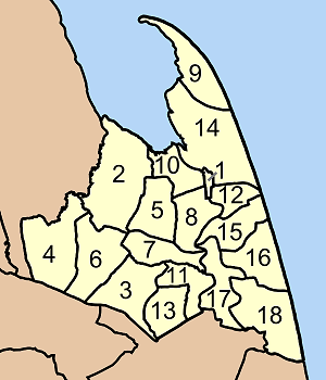
Map of Pak Pahang district, Nakhon Si Thammarat province, Thailand, with the communes (tambon) numbered.
- Pak Phanang (ปากพนัง)
- Khlong Noi (คลองน้อย)
- Pa Rakam (ป่าระกำ)
- Chamao (ชะเมา)
- Khlong Krabue (คลองกระบือ)
- Ko Thuat (เกาะทวด)
- Ban Mai (บ้านใหม่)
- Hu Long (หูล่อง)
- Laem Talumphuk (แหลมตะลุมพุก)
- Pak Phanang Fang Tawantok (ปากพนังฝั่งตะวันตก)
- Bang Sala (บางศาลา)
- Bang Phra (บางพระ)
- Bang Taphong (บางตะพง)
- Pak Phanang Fang Tawan-ok (ปากพนังฝั่งตะวันออก)
- Ban Phoeng (บ้านเพิง)
- Tha Phaya (ท่าพยา)
- Pak Phraek (ปากแพรก)
- Khanap Nak (ขนาบนาก)

| This file is licensed under Creative Commons Attribution ShareAlike 1.0 License |
File history
Click on a date/time to view the file as it appeared at that time.
| Date/Time | Dimensions | User | Comment | |
|---|---|---|---|---|
| current | 12:01, 22 June 2006 | 300×350 (17 KB) | Ahoerstemeier | (Map of Pak Pahang district, Nakhon Si Thammarat province, Thailand, with the communes (tambon) numbered. #Pak Phanang (ปากพนัง) #Khlong Noi (คลองน้อย) #Pa Rakam (ป่าระกำ) #Chamao (ชะเมา) #Khlong Krabu) |
File links
The following pages on the English Wikipedia link to this file (pages on other projects are not listed):

