Quadripoint
From Wikipedia, the free encyclopedia

In geography, a quadripoint is a point on the Earth that touches four distinct regions. Such points are often called "four corners", from the corners of the four regions meeting there[1]
Contents |
[edit] International quadripoints
At present there are no generally recognized quadripoints involving four different countries, although a weak argument could be made that one exists at between Namibia, Zambia, Zimbabwe and Botswana at the thalweg confluence of the Zambezi River with the Chobe River near Kazungula. The various boundary definitions involved are subject to differing and disputed interpretations; only one combination of interpretations will produce a quadripoint.[2] [3]
[edit] Close calls
If the Kazungula case above is not accepted as a quadripoint, it is the place where tripoints are closest together, as the maximum distance between the tripoints is no more than a few hundred metres.
Where two tripoints occur very close to each other, they can look like a quadripoint on a map of insufficient resolution. For example, the Kazakhstan/Russia/People's Republic of China tripoint at is only 39 km from Tavan Bogd Uul, a Russia/Mongolia/People's Republic of China tripoint. It may look like a quadripoint on some maps, but at more detailed resolution, it is clear that Kazakhstan and Mongolia never touch[4].
An even closer example of this is between the tripoints of Armenia/Turkey/Nakhichevan, Azerbaijan and Iran/Turkey/Nakhichevan, Azerbaijan, which are about 9 km from each other at .

Although four countries border Lake Chad, there is no quadripoint of Chad, Niger, Nigeria, and Cameroon within the lake. The two tripoints are about 86 Km apart.
Similarly, the Gulf of Aqaba in the Red Sea borders four countries, but does not contain a quadripoint of Jordan, Saudi Arabia, Egypt, and Israel.
Some political maps of the South Pacific enclose many island nations within straight lines drawn along parallels of latitude or meridians of longitude, often with a maritime quadripoint for Solomon Islands, Tuvalu, Kiribati, and Nauru[5]. This is not a meaningful quadripoint, as the lines are simply cartographic conveniences to indicate which country the landmasses within it belong to; they do not correspond to international boundaries, many of which are undefined, or to territorial waters or Exclusive Economic Zones.[6]
[edit] Previously existing four-country points
Between 1839 and 1919 there was a four-country point at the convergence of Belgium, Prussia/Germany, the Netherlands, and Moresnet. [1] [2]
From 1922 to 1991 there was a de facto quadripoint between Iraq, Kuwait, Kingdom of Nejd/Saudi Arabia and the Saudi-Iraqi neutral zone, although precise boundaries were never specified by the three sovereign states.
[edit] Fewer than four countries
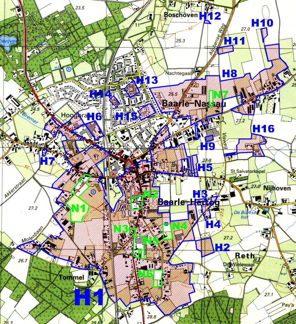
There are quadripoints where four border lines touch each other at one point, but involving fewer than four countries. This occurs with a practical exclave which touches the main territory (or another exclave) at a single point. The Belgian enclaves H1 and H2 in Baarle-Hertog touch each other at one such point, while the Netherlands also crosses it[7].
Similarly, the Austrian town of Jungholz lies totally within Germany except that it borders Austria at one single point.
Cooch Behar in India is linked with Bangladesh at one point.
[edit] Secondary quadripoints
A secondary quadripoint (or "quadrisecondary point") is the meeting of four political subdivisions (for example, provinces, states, or cantons). The four subdivisions may all belong to one country, or they may involve two or three different countries.
By analogy, one could speak of tertiary quadripoints ("quadritertiary points") where, for example, four different towns meet at one point. However, these are not considered particularly interesting. For example, many of the counties of Nebraska are demarcated as squares in a grid.
[edit] Trinational
At , there is a trinational secondary quadripoint: to the northwest is Russia (specifically the Russian exclave Kaliningrad Oblast); to the northeast Lithuania; and to the southwest and southeast two Voivodships (provinces) of Poland: Warmian-Masurian Voivodship and Podlasie Voivodship. [3] The quadripoint exists thanks to the way the border between Poland and Russian SFSR was defined in 1945 by the Potsdam Agreement.
At or around , there appears to be another trinational secondary quadripoint: to the north is Saudi Arabia, to the southeast is Oman, and to the southwest two Governorates of Yemen: Hadhramaut Governorate to the westsouthwest and Al Mahrah Governorate to the southsouthwest.[8]
[edit] Binational
The three German states Bavaria, Saxony, and Thuringia, do not form a quadripoint with the Czech Republic; nevertheless it is frequently commented on.
On the border of Sweden and Norway, at , there appears to be a binational secondary quadripoint where two Counties of Norway, Nord-Trøndelag and Nordland, meet two Counties of Sweden, Västerbotten County and Jämtland County.[8] [4]
[edit] National
The Argentine provinces of La Pampa, Río Negro, Mendoza and Neuquén form a quadripoint at .
The Four Corners is the only point in the United States of America where four states meet: Colorado, Utah, New Mexico, and Arizona meet at right angles.
There has been an analogous Four Corners in Canada at since the creation of Nunavut in 1999; it meets Saskatchewan at a point, with Manitoba and the Northwest Territories at the other corners. Before 1999 this was a tertiary quadripoint, with Manitoba, Saskatchewan, and the then existing Northwest Territories districts of Mackenzie and Keewatin.
Four provinces of the Philippines meet at a point on Mindanao island, probably at one of the three peaks of Mount Apo: Bukidnon, Davao del Norte, Davao del Sur, and Cotabato.
There are two quadripoints in Switzerland where three cantons meet. At each, a practical exclave of one canton touches its parent, while two other cantons touch each other. One is near , where the municipality of Roggenburg is cut off from its parent Basel-Country by Jura to the south and an exclave of Solothurn to the north. The other is near where Jura again touches Solothurn, cutting off the municipality of Schelten from its parent canton of Bern.[9]
[edit] United Kingdom
An analysis of county quadripoints in the United Kingdom is complicated by the fact that the borders and numbers of administrative counties have changed several times in the last century (see Administrative counties of England). No true quadripoints remain in the United Kingdom.
Until the late ninteenth century, one quadripoint did exist; near Evenlode in Gloucestershire, is "Four Shire Stone"[10], formerly at an intersection of Gloucestershire, Oxfordshire, Warwickshire, and a detached fragment of Worcestershire. However, the fragment has been reassigned, leaving only a tripoint around ten miles (16 km) from modern Worcestershire.[11]
In addition there are a few near misses. The most famous lies south west of Stamford – where Rutland, Lincolnshire, Cambridgeshire and Northamptonshire seem to meet at a point. ( ) However, the location actually consists of two tripoints around 20 metres apart.[12]
In addition near East Grinstead, the East Sussex-West Sussex-Surrey and East Sussex-Surrey-Kent tripoints are only a mile apart. Similarly the Staffordshire-Warwickshire-Leicestershire and Warwickshire-Leicestershire-Derbyshire tripoints are again around a mile apart. And until 1965, the two tripoints formed by Gloucestershire, Oxfordshire, Wiltshire and Berkshire near Lechlade came very close to one another. ( ).
[edit] Five or more regions
At subnational level, one can find even more than four divisions converging at a point.
Tertiary five point:
- Five counties in Florida meet within Lake Okeechobee[13]: Okeechobee, Martin, Palm Beach, Hendry, and Glades.
- In the Philippines:
- Municipalities of Tagkawayan, Quezon Province; Labo, San Vicente and San Lorezo Ruiz, Camarines Norte; and Del Gallego, Camarines Sur
- Cities of Cadiz, Sagay, Silay and Talisay, and municipality of Calatrava, Negros Occidental
- Municipalities of Carmen, Batuan, Bilar, Dimiao, and Valencia, Bohol
- Municipalities of San Miguel, Ubay, Alicia, Dagohoy and Pilar, Bohol
- Malaybalay City, Sumilao, Baungon, Talakag and Lantapan, Bukidnon
- Municipalities of Carmen, Aleosan, Pikit and Kabacan, Cotabato; and Pagagawan, Maguindanao
- Municipalities of Tibiao and Barbaza, Antique; Madalag and Libacao (a close call?), Aklan; and Jamindan, Capiz

Tertiary six point:
- Municipalities of Basey and Marabut, Samar; and Balangkayan, Llorente, Balangiga and Lawaan, Eastern Samar, Philippines
Cases of Tertiary octopoints:
- Eight municipalities or towns in Albay, Philippines including Legazpi City meet on the crater of Mayon Volcano.
- Eight municipalities (Aura, Masku, Mynämäki, Nousiainen, Pöytyä, city of Turku, Vahto & Yläne) meet on Kuhankuono boundary mark[14] in the Kurjenrahka national park in Finland Proper. In 2009, Pöytyä and Yläne will merge, "demoting" the point into a seven-point.
[edit] References
This article was originally translated from the Dutch-language wiki article nl:Vierlandenpunt, as of 2006-06-20 [5], with the assistance of SystranBox online machine translation.
- ^ One could argue that, if one region lies on one side of a straight line border, and the other three are on the opposite side of this line, there are only three "corners" plus a straight line. However in geometry the straight line in this context would be considered to form a straight angle measuring 180°.
- ^ Brownlie, Ian; Ian R. Burns (1979). "Botswana-Zambia (Quadripoint issue)", African Boundaries: A Legal and Diplomatic Encyclopaedia. London: C. Hurst & Co., 1098-1108. ISBN 0-903983-87-7.; summarized at African tripoints: Botswana-Namibia-Zambia by Michael Donner / Jesper Nielsen.
- ^ Akweenda, S. (1997-04-23). "VI: Quadripoint Theory", International Law and the Protection of Namibia's Territorial Integrity. Netherlands: Martinus Nijhoff, 201-3. ISBN 90-411-0412-7.
- ^
- ^ One such map is at Image:Oceania ISO 3166-1.svg
- ^ Pacific Map, showing EEZ and 12 nautical miles (22 km) zone. SOPAC. Retrieved on 2006-12-10.
- ^ See The Baarle Enclaves website, including : overview with photograph of the H1-H2 quadripoint and Map including H1 and H2 enclaves
- ^ a b Kallos, Aletheia (2006-06-08). an apparent nose2janontvb binational quadripoint. BoundaryPoint (Yahoo! Groups). Retrieved on 2006-06-20.
- ^ Schuler, Martin; Pierre Dessemontet, Dominique Joye (July 2005). RECENSEMENT FÉDÉRAL DE LA POPULATION 2000: LES NIVEAUX GÉOGRAPHIQUES DE LA SUISSE (PDF), with the collaboration of Manfred Perlik (in French), Neuchâtel: Swiss Federal Statistical Office, p. 22, fn. 12. Retrieved on 2007-01-04. “Juridiquement ..., un seul point de contact définit la qualité de territoire limitrophe. ... ce point de droit a permis que la commune de Roggenburg puisse changer de canton (d’abord vers Berne, puis vers Bâle-Campagne). De même la commune de Schelten n’est pas considérée comme une exclave du canton.”
- ^ Ordnance Survey grid reference for Four Shire Stone: SP231321
- ^ Buchanan, C. A.; Robert Angus Buchanan (1980). The Batsford Guide to the Industrial Archaeology of Central Southern England: Avon County, Gloucestershire, Somerset, Wiltshire. Batsford, p.91. ISBN 0713413646.
- ^ A real quadripoint?. blanchflower.org.
- ^ Counties of Florida map from U.S. Census Bureau.
- ^ Kuhankuono octopoint from National Land Survey of Finland map
[edit] See also
- Tripoint
- Tri-state
- Tri-state area
- Land borders
- Four Corners (Canada)
- Four Corners (United States)
- Four Corners Monument
- Moresnet
- List of countries that border only one other country
- Borderless country
- List of national four-country border sets
[edit] External links
- Geographical Curiosities: Local Geography a larger list of quadrisecondary points, without references.


![[1]](http://commons.wikimedia.org/wiki/Image:Drilandenpunt.jpg)
![[2]](http://nl.wikipedia.org/wiki/Afbeelding:Vierlandenpunt.jpg)