Image:Ph map cavite.png
From Wikipedia, the free encyclopedia
Size of this preview: 569 × 600 pixels
Full resolution (612 × 645 pixels, file size: 76 KB, MIME type: image/png)
| | This is a file from the Wikimedia Commons. The description on its description page there is shown below.
|
| Description |
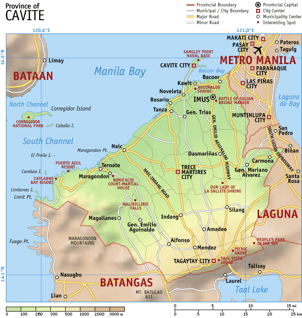
Map of the province of en:Cavite, en:Philippines. It is a topographic map showing the municipalities and cities, major and minor roads, and notable places of interest. Created and copyright (2003) by seav. Released under the GNU FDL. |
|---|---|
| Source |
Originally from en.wikipedia; description page is/was here. |
| Date |
2003-10-11 (first version); 2003-11-07 (last version) |
| Author |
Original uploader was Seav at en.wikipedia |
| Permission (Reusing this image) |
Released under the GNU Free Documentation License. |
[edit] License information

[edit] Original upload log
(All user names refer to en.wikipedia)
File history
Click on a date/time to view the file as it appeared at that time.
| Date/Time | Dimensions | User | Comment | |
|---|---|---|---|---|
| current | 14:19, 3 May 2007 | 612×645 (76 KB) | Ppntori | ({{Information |Description=Map of the province of en:Cavite, en:Philippines. It is a topographic map showing the municipalities and cities, major and minor roads, and notable places of interest. Created and copyright (2003) by [[:en:User:Seav|s) |
File links
The following pages on the English Wikipedia link to this file (pages on other projects are not listed):

