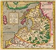
Image:Livland 15jh.png
From Wikipedia, the free encyclopedia

Size of this preview: 666 × 599 pixels
Full resolution (1,000 × 900 pixels, file size: 2.23 MB, MIME type: image/png)
File history
Click on a date/time to view the file as it appeared at that time.
| Date/Time | Dimensions | User | Comment | |
|---|---|---|---|---|
| current | 00:01, 12 November 2006 | 1,000×900 (2.23 MB) | MapMaster | (Beschreibung: Historische Karte von Livland, vermutlich 15. Jahrhundert Description: Historical map of Livonia, likely 15th century Quelle: Erbstück Urheber: unbekannt Datum vermutlich: 15. Jahrhundert Scan by Benutzer:Exxu This is a copy of [[w:de::Bil) |
File links
The following pages on the English Wikipedia link to this file (pages on other projects are not listed):


