User talk:Ingoman
From Wikipedia, the free encyclopedia
[edit] moved your Tunis image to Commons
Hi I moved your image Tunis.png to Commons [[1]] because it was colliding with another image already on the commons called Tunis.png. I updated all the pages that use your image as well to use the new name. Sbwoodside 02:34, 2 November 2005 (UTC)
[edit] Late Ottoman flag
Hi Ingoman, I recently edited the Ottoman Flag article, correcting the information on the relationship between the late Ottoman flag and the flag of Turkey (they are not identical, as was stated in the article). I also replaced, in the Reform and Decline section, the image (Image:Ottoman_Religious1789-1923.png [2]) with (Image:OttomanReligious.png [3]), both uploaded by you. The problem with the first image is that it is clearly a copy of the modern Turkish flag (see Image:Flag of Turkey.svg [4]), recognizable by its clear geometric proportions, painted into green with an image editing tool, and this is not historically accurate. I changed the reference in the article to the second image (Image:OttomanReligious.png) uploaded by you on February, and I am marking the wrong flag image for deletion. Regards, Atilim Gunes Baydin 19:30, 16 August 2006 (UTC)
[edit] Rise of the Islamic Courts
On 25-Sep, you added a {{rfd}} tag to Rise of the Islamic Courts. However, you never listed this redirect at WP:RFD. If you still wish to nominate this redirect for deletion, please complete your nomination. The instructions are listed at WP:RFD. If you don't list it within a reasonable time, I'll assume you don't wish to proceed and remove the tag. Let me know if you have any questions. Thanks! -- JLaTondre 17:56, 8 October 2006 (UTC)
[edit] image question
I left a question at Image talk:Somali land 2006 10 10.png on a point I'm confused about in the description. Thanks, BanyanTree 22:21, 19 October 2006 (UTC)
[edit] Somali Land 2006: congratulations!
Thank you so much! It is by far the best and most relevant map on Somalia available anywhere on the Web. I'll make good use of it here at UQAM in Montreal. Two questions: 1) where did you get the info about all the subdivisions and their exact geographical boundaries? 2) Are they named after sub-clans, or some other convenient way? I mean, I understand the color scheme and who controls what, but I don't know why subdivisions are named the way they are. Paradis pe 02:00, 1 November 2006 (UTC)
- Let me add to these congrulations. :) Another update, BTW: Hobyo is now in the hands of the ICU,(ref) so I think you can delete "Southern Mudug" entirely from the next map update... —Nightstallion (?) 18:29, 1 November 2006 (UTC)
- Sure thing, interesting though, they helped set up Southern Mudug with local elders in mid-August after they drove out the pirate lords there. I think I'm going to draw in Gaalkacayo as being disputed between Puntland and the Islamic Courts, as the southern half of the province is loosely held by ICU-aligned militias, and there are islamic courts in both north and south Gaalkacayo now, as of yesterday, despite the district technically being part of Puntland. --Ingoman 20:00, 1 November 2006 (UTC)
[edit] Your new maps
You mixed up Jubaland and Puntland in a few of the legends -- in some of them, Puntland is given as belonging to the Transitional Government, when you actually meant that Jubaland does. —Nightstallion (?) 14:52, 9 November 2006 (UTC)
- Ahh crap, thanks for that. --Ingoman 16:11, 9 November 2006 (UTC)
- And once again, though my repetition must get on your nerves by now, I am amazed by the quality of your maps on the highly complicated Somalia issue. :) —Nightstallion (?) 20:13, 9 November 2006 (UTC)
- Praise is always appreciated. I've been trying to research the period between 1991 and 2000, but it's difficult because the period is so chaotic. I also wanted to do a map on the Ogaden War, but it's very difficult to get a good account of the WSLF's campaign in the south.—Preceding unsigned comment added by Ingoman (talk • contribs)
- And once again, though my repetition must get on your nerves by now, I am amazed by the quality of your maps on the highly complicated Somalia issue. :) —Nightstallion (?) 20:13, 9 November 2006 (UTC)
Shabelle is reporting that Bardhere, too, has joined the Islamic Courts, so the map will need to be updated. This looks like a very high-maintenance project :). --WikiMarshall 05:53, 18 November 2006 (UTC)
- It's not enough to establish an Islamic Court, otherwise Galkacyo would be part of the ICU as well. I consider territory with an Islamic Court but still controlled by the JVA or Puntland as disputed. The ICU still has to defeat the JVA forces in Bardhere in order to fully control the district. --Ingoman 06:24, 18 November 2006 (UTC)
Basketballplayer90000 has expressed what appear to be some legitimate concerns about this map on my talk page. Can you please address these concerns? I'm neutral aside from the fact that I think your map is very nice looking. shotwell 00:47, 19 November 2006 (UTC)
- From what I have gathered, Basketballplayer9000 is a hardcore Somaliland nationalist, and as such he does not recognize that the eastern regions are disputed between Somaliland and Puntland, or even that Puntland really exists as a state, nor the Transitional Government's authority. Legitimacy means little however, and my maps are based entirely on actual reality on the ground. This reality is: Sool and Sanaaq are not unquestionably Somaliland territory, and are very much in dispute between Puntland and Somaliland. Baidoa and Gedo are still garrisoned by thousands of JVA, Government and Ethiopian soliders, and by no stretch of the imagination could be considered to belong to the ICU (though Gedo is definitely going in that direction) and North Galkacyo still has a few thousands Puntland and Ethiopian forces stationed there.
[edit] Outside Editor on the Somali people page
to shotwell or Ingoman i need one of you to review the somali people page and see wich one is the best
also look at the discussion page where you can see why there is a edit conflict RoboRanks 02:22, 19 November 2006 (UTC)
[edit] Somali Civil War
Sorry. I saw those and I could not figure out what they were. I assumed a new user had tried to wing it with formatting. What do they do? This is the first time I have come across those. KazakhPol 00:46, 3 December 2006 (UTC)
- They keep the floated images from "stacking" the way they do now that you removed them. --Ingoman 01:07, 3 December 2006 (UTC)
[edit] Upload Somalia maps on Commons?
Hi Ingoman
I established the Somalia portal in the German-language Wikipedia and I appreciate your very good and useful maps of the political situation in Somalia. But why don't you upload your maps in the Commons – so that they are available for all Wikipedias – instead of only in the English-language Wikipedia? Regards, Béka 17:49, 5 December 2006 (UTC)
- The maps are in English, though I suppose that's not much of an impediment. I've released the maps to the public domain, so all are free to use them however they wish.--Ingoman 17:55, 5 December 2006 (UTC)
[edit] Somali war
Hi,
see my changes on Somali Civil War (2006). I call you to continue developing the NEW article. --TheFEARgod (Ч) 17:35, 8 December 2006 (UTC)
[edit] Islamic Courts seal
Hi, thanks for adding that graphic, I was looking at the photo you linked it to and it looks like a book underneath the scales, with a black on white Shahada underneath that, I'm going to upload a seal I made based off the photo on my user profile. I think it fits the photo better, but you uploaded the photo so I'll let you be the judge on whether you want to use it or not.Orthuberra 07:58, 9 December 2006 (UTC)
[edit] Re: Somali land 2006 12 02.png
Nice job on this map! It's the kind of thing we need more of on Wikipedia. (BTW, I left a note on your blog; I hope you take it as constructive criticism, & that it doesn't keep you from considering joining WikiProject Ethiopia.) -- llywrch 22:35, 9 December 2006 (UTC)
- Hey thanks! The exact role of the Sabaeans in founding the Axumite Empire and Da'amot is a very contentious issue, and my own opinion in light of the existing evidence is put forth in my blog entry. This is primarily based on the fact that Sabaean and Ge'ez (both the spoken and written language) are both descended from the same root language (Old South Arabian), and that this root language was the language spoken in South Arabia during the time that the Sabaeans would have invaded Eritrea (roughly 800 BC), and that after 800 BC, Sabaeans referred to themselves the "Mukarribs of Saba and Da'amot", or in mordern terms, the Priest-King of Yemen and Eritrea.--Ingoman 22:49, 9 December 2006 (UTC)
Can you provide the source of the data you used to produce commons:Image:Somali land 2006 12 02.png and/or commons:Image:Somali land 2006 11 14.png? It seems there is already a revert contest underway regarding the inclusion of one version versus the other. I would assume we want to include the most recent version, but the bigger issue is: what is the data source? If we can point to a verifiable source for the information presented in the map then we'll have justification to include it (or to favor one vs. the other). I have to admit, I'm reluctant to ask because of both the quality of the map, as well as the time and effort you've invested. You can weigh in at Talk:Somalia#Map but I also left comments at Commons ([5],[6]). Thanks, -- Gyrofrog (talk) 20:45, 19 December 2006 (UTC)
[edit] the fact of sool,sanaag&cayn
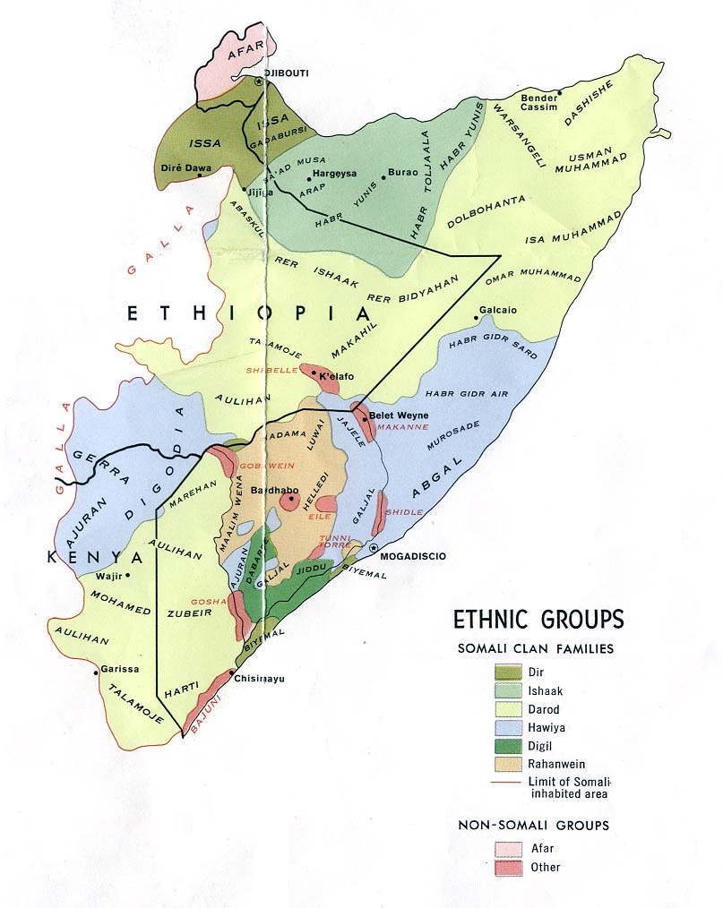
The Somali people in the Horn of Africa were, and still are, the most homogenous people in Africa below the Sahara. They have the same religion, race, culture, language, blood ties and common homeland. Following the European scramble for Africa, the Somali homeland in the Horn of Africa was divided into five parts, creating British Somaliland, Italian Somaliland, French Somaliland (now Djibouti), Ethiopian Somaliland (Ogaden), and the North Eastern region of Kenya (NFD)
The consequence of these colonial conquests was that artificial boundaries were imposed on the Somalis in which clans found themselves divided among the various colonial territories. In the case of British Somaliland, the Darood clans, who inhabit the regions of Sool, Sanaag and Cayn (approximating over 40 percent of the geographical area of the so-called Somaliland), were separated from their fellow clan cousins in Southern Somalia (Puntalnd). So were the Gadabuaursi and Issas whose regions border Djibouti and Ethiopia. Thus, there are no particular common denominators among the clans in former British Somaliland that distinguish them from clans in other neighbouring Somali territories other than the British rule. Rather, they had less blood ties amongst themselves and more with those across the artificial borders in Italian, French, and Ethiopian Somalilands.
It is the artificial division of the Somali homeland in the Horn that served as the driving force for Somali nationalism and the struggle for Somali independence and unity. The five-pointed star of Somalia's national flag symbolizes the aspiration of Somalia's divided people to be free from foreign occupation or domination and that they will eventually unite as one country. The independence of former British and Italian Somalilands and their unity on July first, 1960 was the first realization of this dream. that there were problems soon after independence is an exaggeration. It is true that there were initially some teething administrative problems as was to be expected given that the territories were under colonial powers with different administrative systems for nearly a century. It is also true that the Isaaq clan were somewhat grumpy about losing their former dominance of the North during the time of the British rule. All other clans were indeed very happy to be part of Somalia. If there were problems, they had nothing to do with the Union per se but to historically inherited difficulties or to the wrongs of Somali leaders as later happened.
When the Somali rebel movements succeeded in 1991 to topple the government of the late dictator Siyad Barre, with military help from Ethiopia, the Isaaq clan in the North Western region of Somalia declared their secession from Somalia and adopted the old name colonial name of Somaliland. They had been successful to the extent of propagating the lie that all the other clans in the territory are fully behind this secession. That is a blatant travesty of the facts.. The Darood clans in the territory remain as loyal to their membership of Somalia as they had been since July 1960 when the former British and Italian Somalilands united. So are the overwhelming majority of Gadabuursi and Issa's. But unlike the Daroods in Sool and Sanaag who can fight off the secessionists and repulse any intrusion into their territory, the Gadabuursi have no such advantages. They had suffered atrocities in 1991 from the Isaaq rebel movement (Somali National Movement) and are understandably not keen for the time being to provoke any military reprisals from the Isaaqs, unless thy can count on the support of an effective and functioning Somali government in Mogadishu which can come to their aid.
there is a “dispute” over Sool and Sanaag between Puntland and Somaliland is ludicrous. Puntland (including Sool and Sanaag) is part and parcel of Somalia just as the rest of Somaliland is. To suggest that there is a dispute between Somalia and Somaliland is to imply that Somaliland is itself not part of Somalia. It also implies that the people in the area under “dispute” do not exist or else that their voice/wishes do not count. There some writer may be a victim of the secessionist’s disinformation that Puntland had grabbed regions belonging to Somaliland. This interpretation is possible since writers or journalists visiting Hargeisa rarely ever go to the regions in question; Sool,cayn and Sanaag and ascertain for themselves what the true facts are: that it is the people in Sool and Sanaag regions who took the initiative to join the Puntalnd administration rather than the other way round. A rebel entity, based on one clan, has no legal basis to claim regions belonging to other clans, whose inhabitants had repeatedly made clear that they have nothing to do with the secession. Sool, Sanaag and Cayn regions had never participated in the elections except part of caynaba district(sool) and 21.23% sanaag(west of sanaag) include part of ceerigaabo when I say cerigabo is meaning the town where four tribes inhabitants(isaaq: habaryoonis,habarjeclo and darod:dhulbahante,warsangeli) that only the town that is true the town is ruled by hargeysa administration but the more pawore full is authority of four tribes sometime very thing change in persecond then back into the normal. there will be war between the Daroods and the Isaaqs over Sool and Sanaag specaility in ceerigaabo town.
I like to inform you mr. James Dahl in your last map you miss some thing there are area not contorled by any one.it ruled by tribes(graad&suldaan each of Dhulbahante and warsangeli) all area east of ceerigaabo(arigavo) district. If you see somalia district you know sanaag is five district they are:
1.Ceerigaabo isaaq,dhulbahante,warsangeli(you loss this area your map) Include :masagan,ceelaqoday,madare,ardaa,dhaxamo,biyoguduud,jiidali,fiqi fuleye,awrboogays,dhaabeeda,ceelqoxle ,xingalool,damalaxagare,yube,carmale,bir xamar,dabablehe [fallingrain] [statoids] [maplandia] [multimap] [geocities ] Northern Somali sultanates 2.Badhan warsangeli 3.Ceelafweyn habarjeco&habaryoonis 4.Laasqoray warsangeli 5'Dhahar warsangeli
I like to refer here your map is not including this area above(east arigavo district)
Before british colonial if you look the history you see Makhir Coast (19th century Commercial center in Warsangeli Country) and also history of daraawiish [somaliawatch] [loc] [mudugonline ] [prohosting ] [geocities ] History of Somalia
the former colonial powers, Britain and Italy, do not see eye to eye about the Somalia’s problem and its solution. Nothing Britain has said or done can be interpreted that way. On the contrary, Britain has always joined other UN security members and its EU members to support Somalia unity. So has Italy. Britain had never given any false hopes to the secessionists regarding possible recognition. On the contrary, it has repeatedly advised them to settle their problems with their fellow brothers in Somalia.
“dispute or question about Somaliland’s status. It has no other status other than being a region of Somalia. That is the status that the international community recognizes as of now. If we say that the area be recognized as an independent country separate from Somalia, that is not the way to peace. It is a sure prescription for fanning the flames of the Somali civil war. Inevitably, there will be war between the Daroods and the Isaaqs over Sool and Sanaag. One can also envisage intervention by the Somali government – assuming it overcomes its present difficulties That augurs ill for the stability of the Horn and Africa as a whole. It is in the interest of peace that the clan-based secession be discouraged. In today’s Federal democratic Somalia, regions have more or less self autonomy. The Isaaq-dominated secessionists in the North have everything to gain by playing their full part in Somalia. To refuse unity is to unite the rest of the Somali people against them. Sooner or later, there is bound to be action from a future more effective and powerful government in Somalia. This time, the secessionists will not be facing Siyad Barre and its dreaded regime but the rest of the Somali people.
--Sanaaglander 12:31, 20 December 2006 (UTC)osman hr
[edit] the problem sool,sanaag&buhoodle
hello mr. James Dahl
I think you didn't get the point I referred it in the past comment there are area you excepted in your map the lines extended in the conflict area between puntland and somaliland {ceerigaabo(arigavo) district}Include :masagan,ceelaqoday,madare,ardaa,dhaxamo,biyoguduud,jiidali,fiqi fuleye,awrboogays,dhaabeeda,ceelqoxle ,xingalool,damalaxagare,yube,carmale,bir xamar,dabablehe look map of ceerigaabo: [fallingrain] that mean that area is inhabitants by isaq clan or belong them but that is not true it is big mistake to refer area for one clan to other clan.reason of conflict is distribute of the tribes if you look map of somali clan families you see: [lib.utexas]
the puntland need to make harti state look map of puntland: [biyokulule] include all area inhabitants by harti clan,
where somaliland need to make isaaq nation in the boundaries of the new republic are the same as those of "British Somaliland [somalilandgov] that is impossible because who inhabit the regions of Sool, Sanaag and Cayn (approximating over 40 percent of the geographical area of the so-called Somaliland), were separated from their fellow clan cousins in Southern Somalia (Puntalnd).here I execept he Gadabuursi,They had suffered atrocities in 1991 and occupied from the Isaaq rebel movement (Somali National Movement) and are understandably not keen for the time being to provoke any military reprisals from the Isaaqs, unless thy can count on the support of an effective and functioning Somali government in Mogadishu which can come to their aid when somalia get central govertment.
mr. James Dahl you said(Sool and Sanaaq are disputed between Puntland and Somaliland, because some of the Qabiil wish to be part of Puntland and some other Qabiil want to be part of Somaliland.)
that is not true,there some people used by name in the hargeysa administration to give them money or other advantages there usually are some chief sub-clan they use them to the extent of propagating the lie that all the other clans in the territory are fully behind this secession. That is a blatant travesty of the facts.. those people we can count them by name, the problem not those poeple or what are they problem is reason of the conflict.
I think mr james your map is same map of Max Planck Institute for Social Anthropology they are some write are be a victim of the secessionist’s disinformation that Puntland had grabbed regions belonging to Somaliland. This interpretation is possible since writers or journalists visiting Hargeisa rarely ever go to the regions in question; Sool,cayn and Sanaag and ascertain for themselves what the true facts are: that it is the people in Sool and Sanaag regions who took the initiative to join the Puntalnd administration rather than the other way round.A rebel entity, based on one clan, has no legal basis to claim regions belonging to other clans
mr james your map must be basis the somali clan families map because that part of somalia unlike other parts of somalia so be becarefull that is reason of the confilict and your intersection lines must be cover all harti area in sool,sanaag and cayn using tha map of somali clan families :
- [lib.utexas]
- this correct and usefull map of harti part in former british [economist]
mr james you must know too that the people of Sool and Sanaag, as members of major Somali clans, have recognized borders. It is a well defined border, with longitude and latitude; it is borders well recognized by Her Majesty, the British Kingdom; it is a border that recognizes where the Isaq sub-clans reside and where the Harti sub-clans are too. don't disturb those borders and the peace. --Sanaaglander 19:01, 21 December 2006 (UTC)--osman hr
[edit] Maps
Say, wouldn't it be time for a new map about now? —Nightstallion (?) 15:35, 23 December 2006 (UTC)
- Definitely. I was waiting for enough territory to change hands as to actually show up on the map. I think I left Jubaland and Southwestern Somalia on the map too long. Both alliance based TFG-aligned states have disintegrated, with parts allying themselves with the ICU or joining the TFG entirely. I may go back and change this. --Ingoman 00:13, 24 December 2006 (UTC)
- Yeah, that may be a fact. If you do so, please also update the articles on Jubaland and Southwestern Somalia -- I'm fairly certain they're horribly out of date with these recent developments. Once again, thanks for your great coverage of these events on Wikipedia! —Nightstallion (?) 00:22, 24 December 2006 (UTC)
- Thank you for uploading some very nice maps of the situation in Somalia. It is great work, please keep them coming. However, I am a bit puzzled by your spelling for "Djibouti". Could you please look into this issue? Happy editing. Valentinian (talk) / (contribs) 11:47, 27 December 2006 (UTC)
- I know you've heard it all before, but your maps are absolutely fantastic. I was amazed when I saw that they were all mad and updated by one person. I've been following the conflict, using wikipedia before news sites, because the article is so useful, the maps are an integral part of that and really put it all in one place to see whats going on. Please keep them up! 8:30, 28 December 2006
- Thanks! :) --Ingoman 09:00, 28 December 2006 (UTC)
- I'll echo that sentiment! They're really nice, one of the most clear maps currently to be found on the conflict. Could you enlighten me as to where you get all your information from? Cheers! The Minister of War (Peace) 14:47, 28 December 2006 (UTC)
- Well the map is constructed from district maps of Somalia, Kenya and Ethiopia. When the seat of that district is taken by one side or another, I change the map. The background information of the map took a while to build, but once that was done it was easy. --Ingoman 21:29, 28 December 2006 (UTC)
- I'll echo that sentiment! They're really nice, one of the most clear maps currently to be found on the conflict. Could you enlighten me as to where you get all your information from? Cheers! The Minister of War (Peace) 14:47, 28 December 2006 (UTC)
- Thanks! :) --Ingoman 09:00, 28 December 2006 (UTC)
[edit] Hello
I see that you create some pretty useful stuff (like Image:Icu flag.svg), it would save a lot of trouble for people on other wikipedias if you would just upload them to commons right away :) Keep up the good work notwist 10:55, 29 December 2006 (UTC)
[edit] Maps again...
I've read that Ethiopia claims to controll 95% of "the territory"; I assume they mean "of the territory not under the controll of Puntland or Somaliland", but still, the last map you made has them controlling far less... I assume they controll next to everything except for Kismayo? —Nightstallion (?) 15:09, 29 December 2006 (UTC)
Hi there.So what's the status in Somalia today?I heard that the Islamic Courts lost control of almost all of their territories.Dimts 10:57, 30 December 2006 (UTC)
[edit] Re: Failed GA on Rise of the Islamic Courts Union (2006)
I primarily failed the article because it was a current event. I was only following a guideline and I'm afraid I'm not experienced enough to judge a political article. Renominate it for someone else to do so. Have a nice day, and do post on my actual talk page rather than my user page. Wiki-newbie 18:43, 29 December 2006 (UTC)
[edit] ...and again
Allow me to heap on another kudos for your Somalia maps. They are part of what makes Wikipedia great. And a question too -- what is your source for the district boundaries. I've seen the ElectionWorld outline map (Image:Somalia districts.png) but never one with more detail. Thanks. — AjaxSmack 08:17, 8 January 2007 (UTC)
- Thanks for the links and all your work. — AjaxSmack 00:49, 9 January 2007 (UTC)
 |
The Graphic Designer's Barnstar | |
| For your prolific contributions to War in Somalia (2006–present) and Rise of the Islamic Courts Union (2006), the presence of which maps has served remarkably to improve such article and the precision of which is unparalled, you are to be commended. Joe 06:10, 9 January 2007 (UTC) |
[edit] ICU flag
What is actually the flag of the Islamic courts union this: Image:Icu flag.svg or this: ![]() ? Kermanshahi 08:59, 2 June 2007 (UTC)
? Kermanshahi 08:59, 2 June 2007 (UTC)
[edit] Hey!
Great to see you're active again! What's the latest news on the reconciliation conference? Likely to bring any changes for the better? —Nightstallion 19:26, 21 August 2007 (UTC)
[edit] Maakhir
I noticed that there were two people editing and I didn't look to see who did what so this may not apply to you. I've cleaned up the links (and made no other changes to the article) and just wanted to let you know the following. In the body of the article there should only be one link to other articles. In other words the first time that "Somaliland" is in the article link it, but not every time it appears. Also, please don't make direct links into redirects. The following are direct links to articles: Jibrell Ali Salad (Jibrell Ali Salad Aadan), Warsangali (Warsangeli), Mohamud Muse Hersi (Adde Musa), Dhulbahante (Dulbahante), Majeerteen (Majerteen), Las Khorey (Laasqoray) and Ceerigaabo (Erigavo). Also watch out for Dhahar which is just a redirect to Sanaag and not a link to the town. CambridgeBayWeather (Talk) 23:38, 25 August 2007 (UTC)
[edit] New map

Hi! I noticed your new map. It's very useful for a new article I started, 2007 Ogaden conflict (join me in editing it :). One little thing: you haven't put a soldier of the Islamist insurgency in Mogadishu. --TheFEARgod (Ч) 13:39, 3 September 2007 (UTC)
- Consider using this map as a source --TheFEARgod (Ч) 14:09, 3 September 2007 (UTC)
[edit] Maakhir
I was just looking at the Regions and Districts section. Do you know which districts of Somalia/Somaliland/Puntland the new Heylaan and Western Bari are made from? It appears from the map that at least part of Sool is included. If so can you add it to that section. Thanks. CambridgeBayWeather (Talk) 15:07, 6 September 2007 (UTC)
- OK thanks. CambridgeBayWeather (Talk) 15:16, 6 September 2007 (UTC)
[edit] Islamist insurgency in Somalia (2007–present)
You made a little mistake at the page Islamist insurgency in Somalia (2007–present). You put the name of the insurgency as the Muqawaama. That, in Arabic, is a wide term meaning "resistance", so it would be no help for thae name of the movement as there are many Moqawamas. --TheFEARgod (Ч) 11:59, 8 September 2007 (UTC)
[edit] Maakhir
Which bit did you mean. The references are too small to read on larger monitors, templates usually go at the bottom and not everybody knows what Eng. or Prof. stands for. CambridgeBayWeather (Talk) 07:26, 9 September 2007 (UTC)
[edit] New article of interest to you
Have you seen Alliance for the Liberation of Somalia yet? —Nightstallion 19:01, 12 September 2007 (UTC)
- This should be interesting, though bloody, months ahead for Somalia. --Ingoman 20:10, 12 September 2007 (UTC)
- I'm afraid that may indeed be the case -- though if the outcome is a central government of *any* sort, it'd be an improvement, I reckon... —Nightstallion 23:32, 12 September 2007 (UTC)
- I don't know, I think things would be ok if the country just went ahead and totally fragmented. A central government of Somalia, to hold things together, would have to be basically totalitarian. --Ingoman 04:30, 13 September 2007 (UTC)
- Possibly, but what's the alternative? —Nightstallion 16:56, 14 September 2007 (UTC)
- I don't know, I think things would be ok if the country just went ahead and totally fragmented. A central government of Somalia, to hold things together, would have to be basically totalitarian. --Ingoman 04:30, 13 September 2007 (UTC)
- I'm afraid that may indeed be the case -- though if the outcome is a central government of *any* sort, it'd be an improvement, I reckon... —Nightstallion 23:32, 12 September 2007 (UTC)
[edit] Image copyright problem with Image:Karaman.png
Thank you for uploading Image:Karaman.png. However, it currently is missing information on its copyright status. Wikipedia takes copyright very seriously. It may be deleted soon, unless we can determine the license and the source of the image. If you know this information, then you can add a copyright tag to the image description page.
If you have any questions, please feel free to ask them at the media copyright questions page. Thanks again for your cooperation. The Evil Spartan 19:18, 27 September 2007 (UTC)
[edit] News
Hi! Say, what's going on in Somalia right now? Apart from the foundation of the United Somali Parliamentarians to support the PM -- is anything going forward? What's with the border changes of Maakhir, Puntland and Somaliland? Thanks! —Nightstallion 02:18, 27 October 2007 (UTC)
[edit] New PM
Could you write a short article on Salim Aliyow Ibrow, the new PM? Thanks! —Nightstallion 16:34, 29 October 2007 (UTC)
[edit] Image:Ottoman_Empire1517-1844.png listed for deletion
An image or media file that you uploaded or altered, Image:Ottoman_Empire1517-1844.png, has been listed at Wikipedia:Images and media for deletion. Please see the discussion to see why this is (you may have to search for the title of the image to find its entry), if you are interested in it not being deleted. Thank you. OsamaK 19:18, 15 November 2007 (UTC)
[edit] Oil exploration in Puntland
--Elkman (Elkspeak) 14:37, 15 January 2008 (UTC)
[edit] Disputed fair use rationale for Image:Canoecarving.jpg
Thanks for uploading Image:Canoecarving.jpg. However, there is a concern that the rationale you have provided for using this image under "fair use" may be invalid. Please read the instructions at Wikipedia:Non-free content carefully, then go to the image description page and clarify why you think the image qualifies for fair use. Using one of the templates at Wikipedia:Fair use rationale guideline is an easy way to ensure that your image is in compliance with Wikipedia policy, but remember that you must complete the template. Do not simply insert a blank template on an image page.
If it is determined that the image does not qualify under fair use, it will be deleted within a couple of days according to our criteria for speedy deletion. If you have any questions please ask them at the media copyright questions page. Thank you.BetacommandBot (talk) 19:03, 13 February 2008 (UTC)
[edit] Barnstar
 |
The Somalian Barnstar of National Merit | |
| I, Ahmed, hereby award you the 'Somalian Barnstar of National Merit' for your extensive contributions to Somali-related articles, especially on the Somali Civil War articles. -- yariiska (talk) 12:25, 29 February 2008 (UTC) |
[edit] Why did you delete my image?
Hi, sorry about this. Admin Ahonc is known in ukWP for "Ahonc wars". He was ultimately desysoped. After that some users noticed that Ahonc is executing his revenge (e.g., uk:Вікіпедія:Запити до адміністраторів/Ahonc wars 99… 999… 999999999999999999999 ???}. As you may see in commons:Commons:Administrators/Requests and votes/Ahonc, Ahonc did not mention the fact of his desysoping. Because of his practice of removing images on technicalitites without adequate prior notice, some users at ukWP are considering moving all their files from Commons back to ukWP. Perhaps Ahonc is trying to make his name known worldwide. Sorry once again,--Sk741 (talk) 08:31, 8 June 2008 (UTC)


![[1]](http://commons.wikimedia.org/wiki/Image:Tunis_hafsid_flag.png)
![[2]](http://en.wikipedia.org/wiki/Image:Ottoman_Religious1789-1923.png)
![[3]](http://en.wikipedia.org/wiki/Image:OttomanReligious.png)
![[4]](http://en.wikipedia.org/wiki/Image:Flag_of_Turkey.svg)
![[5]](http://commons.wikimedia.org/wiki/Image_talk:Somali_land_2006_12_02.png)
![[6]](http://commons.wikimedia.org/wiki/Image_talk:Somali_land_2006_11_14.png)