Image:Iberian Peninsula antique map.jpg
From Wikipedia, the free encyclopedia
Size of this preview: 739 × 599 pixels
Full resolution (2,096 × 1,700 pixels, file size: 5.81 MB, MIME type: image/jpeg)
| | This is a file from the Wikimedia Commons. The description on its description page there is shown below.
|
| This is a featured picture, which means that members of the community have identified it as one of the finest images on the English Wikipedia, adding significantly to its accompanying article. If you have a different image of similar quality, be sure to upload it using the proper free license tag, add it to a relevant article, and nominate it. |
| This image was selected as picture of the day on the English Wikipedia for November 11, 2007. |
This is a featured picture on English Wikipedia and is considered one of the finest images.
|
[edit] Summary
| Description |
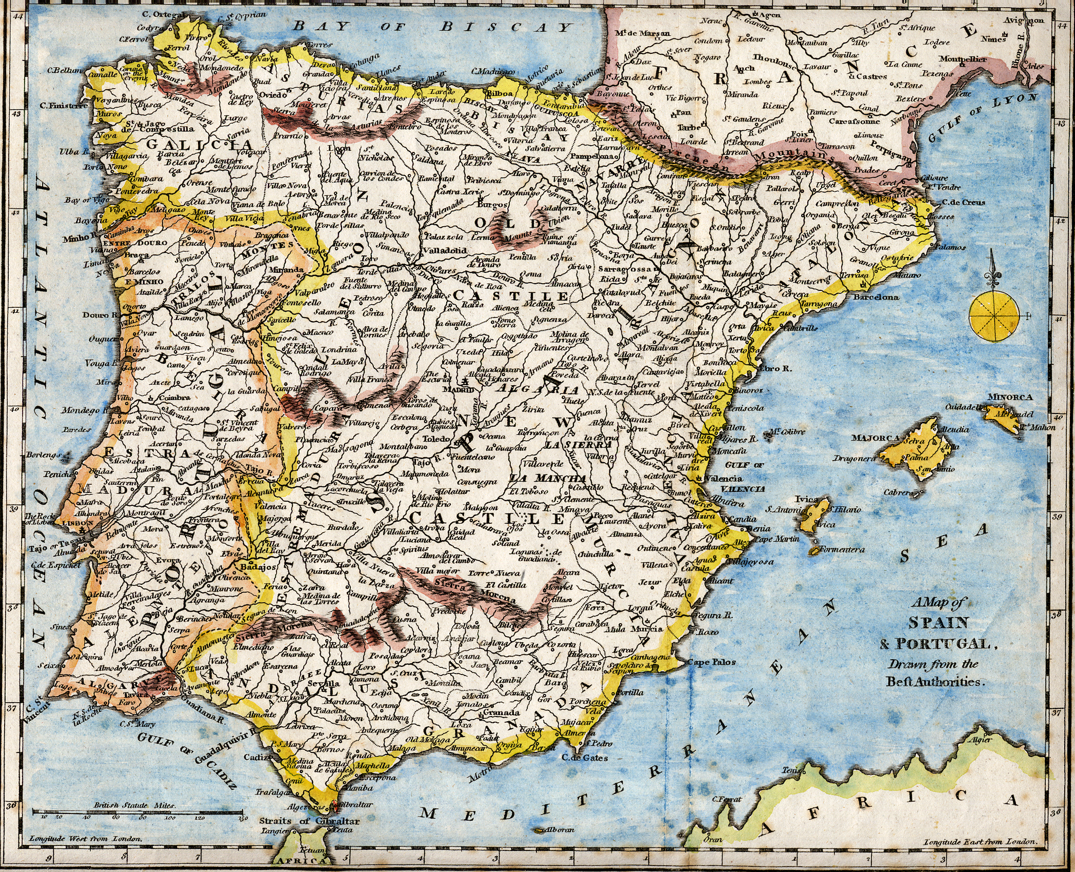
English: 18th century hand-coloured engraved map of the Iberian peninsula depicting various topographical features of the land, as published in Robert Wilkinson's General Atlas, circa 1794. (Volume 2., page 666.)
Titl'd A Map of Spain & Portugal, Drawn from the Beſt Authorities Español: Mapa del siglo XVIII grabado al cobre e iluminado a mano, representando varias características topográficas de la Península Ibérica. Publicado en el atlas general de Robert Wilkinson (volumen 2., página 666.)
Português: Mapa do século XVIII gravado em cobre e iluminado a mão, representando várias características topográficas da Península Ibérica. Publicado no atlas geral de Robert Wilkinson (volume 2., página 666.)
|
|---|---|
| Source |
Scanned from my personal collection. |
| Date |
circa 1794 |
| Author |
Robert Wilkinson (scanned by en:User:Chris.B / User:RedCoat) |
| Permission (Reusing this image) |
see below |
[edit] Licensing
| This image (or other media file) is in the public domain because its copyright has expired. This applies to the United States, Canada, the European Union and those countries with a copyright term of life of the author plus 70 years.
العربية | Asturianu | Български | Català | Česky | Dansk | Deutsch | English | Ελληνικά | Esperanto | Español | Euskara | فارسی | Français | Gaeilge | Galego | עברית | हिन्दी | Bahasa Indonesia | Italiano | 日本語 | 한국어 | Kurdî / كوردی | Lietuvių | Magyar | Nederlands | Norsk (nynorsk) | Bahasa Melayu | Polski | Português | Română | Русский | Slovenčina | Slovenščina | Shqip | Suomi | Sámegiella | Türkçe | 中文(简体) | 中文(繁體) | 粵語 | +/- |

File history
Click on a date/time to view the file as it appeared at that time.
| Date/Time | Dimensions | User | Comment | |
|---|---|---|---|---|
| current | 17:01, 28 October 2007 | 2,096×1,700 (5.81 MB) | RedCoat | ({{Information | Description ={{en|18th century hand-coloured engraved map of the Iberian peninsula depicting various topographical features of the land, as published in Robert Wilkinson's ''General Atlas'', circa 1794. ) |
File links
- History of Spain
- Iberian Peninsula
- Portal:Atlas/Selected picture
- Wikipedia:Featured pictures/Diagrams, drawings, and maps
- Wikipedia:WikiProject Gibraltar
- Wikipedia:Featured picture candidates/July-2007
- Wikipedia:Wikipedia Signpost/2007-07-23/Features and admins
- Wikipedia:Featured picture candidates/Iberian peninsula map
- Wikipedia:Featured pictures thumbs 09
- Wikipedia:Wikipedia Signpost/2007-07-23/SPV
- User:Chris.B/Gallery
- Robert Wilkinson (mapmaker)
- User talk:Chris.B/Archive 2
- Portal:Atlas/Selected picture/9
- Wikipedia:Picture of the day/November 2007
- Template:POTD/2007-11-11
- Template:POTD protected/2007-11-11
- User talk:Chris.B/Archive 3
- Wikipedia:Featured pictures/Diagrams, drawings, and maps/Maps
Metadata
This file contains additional information, probably added from the digital camera or scanner used to create or digitize it. If the file has been modified from its original state, some details may not fully reflect the modified file.
| Orientation | Normal |
|---|---|
| Horizontal resolution | 200 dpi |
| Vertical resolution | 200 dpi |
| Software used | Adobe Photoshop Elements 2.0 |
| File change date and time | 22:34, 16 June 2007 |
| Color space | 65535 |

