Image:Guyana-Potaro-Siparuni.png
From Wikipedia, the free encyclopedia
No higher resolution available.
Guyana-Potaro-Siparuni.png (150 × 218 pixels, file size: 4 KB, MIME type: image/png)
| | This is a file from the Wikimedia Commons. The description on its description page there is shown below.
|
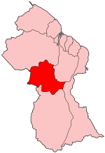
Map of Guyana showing Potaro-Siparuni region.
Source: Made by User:Golbez
| This file is licensed under Creative Commons Attribution ShareAlike 2.0 License (cc-by-sa-2.0). In short: you are free to share and make derivative works of the file under the conditions that you appropriately attribute it, and that you distribute it under this or a similar cc-by-sa license. |
\
File history
Click on a date/time to view the file as it appeared at that time.
| Date/Time | Dimensions | User | Comment | |
|---|---|---|---|---|
| current | 03:30, 2 July 2005 | 150×218 (4 KB) | Golbez | (Map of Guyana showing Potaro-Siparuni region. Source: Made by User:Golbez {{cc-by-sa-2.0}} Category:Maps of Guyana\) |
File links
The following pages on the English Wikipedia link to this file (pages on other projects are not listed):

