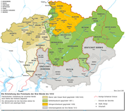
Image:Geschichte Graubuenden.png

From Wikipedia, the free encyclopedia

Wikimedia Commons logo This is a file from the Wikimedia Commons. The description on its description page there is shown below.
Commons is a freely licensed media file repository. You can help.

[edit] Beschreibung

Description

Historische Karte zur Geschichte des Freistaats der Drei Bünde (Graubünden)

Source

own work, basiert auf: Adolf Gasser und Ernst Keller, Historische Karte zur territorialen Entwicklung der Schweizerischen Eidgenossenschaft 1291–1797. o.O. 1932.

Date

13.10.2006

Author

Marco Zanoli (sidonius 11:39, 13 June 2006 (UTC))

Permission
(Reusing this image)
The copyright holder, Marco Zanoli, would be delighted if you could send him a short notice and a specimen copy, if you use his work outside of wikipedia.
CC
BY  SA
This file is licensed under the Creative Commons Attribution ShareAlike 3.0 Unported License. In short: you are free to share and make derivative works of the file under the conditions that you appropriately attribute it, and that you distribute it only under a license compatible with this one.

العربية | Català | Česky | Deutsch | Ελληνικά | English | Esperanto | Español | Français | Italiano | עברית | 日本語 | 한국어 | Magyar | Nederlands | Plattdüütsch | Polski | Português | Русский | Svenska | Tiếng Việt | Українська | +/-

Other versions
Die Entstehung des Freistaats der Drei Bünde
,
Adlige Herrschaften in Graubünden um 1367

[edit] Licensing

I, the copyright holder of this work, hereby publish it under the following license:
Creative Commons License
Creative Commons Attribution iconCreative Commons Share Alike icon
This file is licensed under the Creative Commons Attribution ShareAlike 2.5 License. In short: you are free to share and make derivative works of the file under the conditions that you appropriately attribute it, and that you distribute it only under a license identical to this one. Official license

File history

Click on a date/time to view the file as it appeared at that time.

Date/TimeDimensionsUserComment
current09:28, 7 August 20062,000×1,866 (1.18 MB)Sidonius
16:58, 16 June 20062,000×1,866 (1.17 MB)Sidonius
13:57, 13 June 20061,514×1,410 (530 KB)Sidonius
11:39, 13 June 20061,892×1,765 (699 KB)Sidonius ({{Information| |Description=Historische Karte zur Geschichte des Freistaats der Drei Bünde (Graubünden) |Source=own work, basiert auf: Adolf Gasser und Ernst Keller, Historische Karte zur territorialen Entwicklung der Schweizerischen)
No pages on the English Wikipedia link to this file. (Pages on other projects are not counted.)