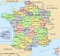
Image:France departements regions narrow.jpg

From Wikipedia, the free encyclopedia

Wikimedia Commons logo This is a file from the Wikimedia Commons. The description on its description page there is shown below.
Commons is a freely licensed media file repository. You can help.
Description

Map of official départements and régions of France, with French titles (in JPEG format for larger, rapid display: 5x faster than SVG). French: Départements et régions, en Francais.

Source

Image:Départements+régions (France).svg (Wikimedia file, converted to quick JPEG and narrowed 15%)

Date

21-March-2007

Author

self (after User:Historicair 6-Nov-2006)

Permission
(Reusing this image)
Public domain I, the copyright holder of this work, hereby release it into the public domain. This applies worldwide.

In case this is not legally possible:
I grant anyone the right to use this work for any purpose, without any conditions, unless such conditions are required by law.


Afrikaans | Alemannisch | Aragonés | العربية | Asturianu | Български | Català | Česky | Cymraeg | Dansk | Deutsch | Eʋegbe | Ελληνικά | English | Español | Esperanto | Euskara | Estremeñu | فارسی | Français | Galego | 한국어 | हिन्दी | Hrvatski | Ido | Bahasa Indonesia | Íslenska | Italiano | עברית | Kurdî / كوردی | Latina | Lietuvių | Latviešu | Magyar | Македонски | Bahasa Melayu | Nederlands | ‪Norsk (bokmål)‬ | ‪Norsk (nynorsk)‬ | 日本語 | Polski | Português | Ripoarisch | Română | Русский | Shqip | Slovenčina | Slovenščina | Српски / Srpski | Svenska | ไทย | Tagalog | Türkçe | Українська | Tiếng Việt | Walon | ‪中文(简体)‬ | ‪中文(繁體)‬ | zh-yue-hant | +/-

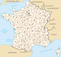
Other versions Wider view, large 254kb SVG file: Image:Départements+régions (France).svg


Atelier graphique
Remarque
English: This map was made or improved by the Wikigraphists of the Atelier graphique. You can propose maps or images to clean up and improve as well.
Esperanto: Ĉi tiu mapo estis kreita aŭ plibonigita de la Vikigrafistoj el la Grafika laborgrupo. Vi ankaŭ povas tie proponi mapojnbildojn plibonigendajn.
Español: Este mapa ha sido confeccionado o mejorado por los Wikígrafos del Taller gráfico. Puedes proponer la mejora de cualquier imagen a través de la página de Peticiones.
Français : Cette carte a été créée ou améliorée par les Wikigraphistes de l'Atelier graphique. Vous pouvez également y proposer des cartes ou des images à améliorer.
Türkçe: Bu harita Atelier graphique'ten Wikigraphistes'ler tarafından yapıldı veya geliştirildi. Siz de haritalar veya resimleri temizlemek veya geliştirmek için teklif edebilirsiniz.


A vector version of this image (SVG) is available.
It should be used in place of this raster image when superior.


Image:France departements regions narrow.jpg  Image:Départements+régions (France).svg

For more information about vector graphics, read about Commons transition to SVG.
There is also information about MediaWiki's support of SVG images.


Български | Deutsch | English | Español | Français | Galego | עברית | Magyar | Bahasa Indonesia | Italiano | 日本語 | 한국어 | Lietuvių | Polski | Português | Русский | Српски / Srpski | Українська | ‪中文(简体)‬ | ‪中文(繁體)‬ | +/-

New SVG image

[edit] Variations

File history

Click on a date/time to view the file as it appeared at that time.

Date/TimeDimensionsUserComment
current13:44, 21 March 2007520×550 (68 KB)Wikid77 (Circled Paris in maroon red color, to tie inset to Paris region.)
12:02, 21 March 2007520×550 (68 KB)Wikid77 ({{Information |Description=Map of official départements and régions of France, with French titles (in JPEG format for larger, rapid display: 5x faster than SVG). ''French:'' Départements et régions, en Francais. |Source=[[:Image:Départements+région)
The following pages on the English Wikipedia link to this file (pages on other projects are not listed):