Image:Battle of Beersheba map.png
From Wikipedia, the free encyclopedia
Size of this preview: 731 × 599 pixels
Full resolution (800 × 656 pixels, file size: 66 KB, MIME type: image/png)
| | This is a file from the Wikimedia Commons. The description on its description page there is shown below.
|
| Description |
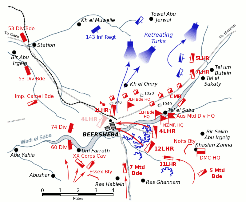
Positions of forces at dusk on October 31, 1917, during the Battle of Beersheba at the time of the charge of the 4th Light Horse Brigade. British forces are shown in red, Turkish forces are shown in blue. The position reached by the regiments of the 4th Light Horse Brigade after the attack is shown in pale red. |
|---|---|
| Source |
Based on Map 15, Ch.23 Vol.VII "Sinai & Palestine" of the Official History of Australia in the War of 1914-18 by H.S. Gullett. |
| Date |
12 April 2004 |
| Author |
Originally uploaded to En Wikipedia by Gsl |
| Permission (Reusing this image) |
see below |
| This image has been (or is hereby) released into the public domain by its author, Gsl at the English Wikipedia project. This applies worldwide. In case this is not legally possible: |
File history
Click on a date/time to view the file as it appeared at that time.
| Date/Time | Dimensions | User | Comment | |
|---|---|---|---|---|
| current | 08:36, 3 November 2007 | 800×656 (66 KB) | Rcbutcher | ({{Information |Description=Positions of forces at dusk on October 31, 1917, during the Battle of Beersheba at the time of the charge of the 4th Light Horse Brigade. <p>British forces are shown in red, Turkish forces are shown i) |
File links
The following pages on the English Wikipedia link to this file (pages on other projects are not listed):

