Artsakh
From Wikipedia, the free encyclopedia
|
|
This article may require cleanup to meet Wikipedia's quality standards. Please improve this article if you can. (May 2008) |
- For the republic, see Artsakh Republic

This article is part of the series on: |
|||
| Early History | |||
| Artsakh | |||
| ' | |||
| Persian Rule | |||
| Karabakh Khanate | |||
| Imperial Russian Rule | |||
| Early 20th Century | |||
| History (1915-1921) | |||
| Sovietization | |||
| Soviet Rule | |||
| Nagorno-Karabakh Autonomous Oblast | |||
| Independence | |||
| Nagorno-Karabakh War | |||
| Republic of Nagorno-Karabakh | |||
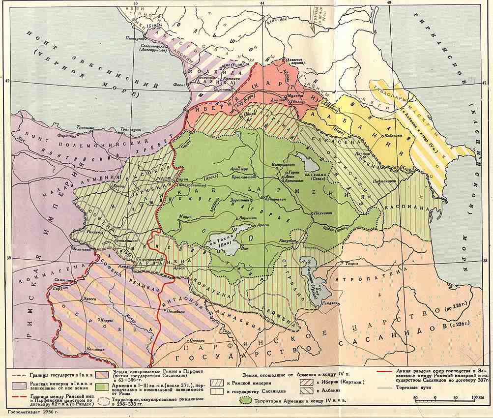
Artsakh (Armenian - Արցախ), was a province of the Armenian Kingdom, and after 387 C.E. of Caucasian Albania[1][2][3] [4] and covered what is now mostly Nagorno-Karabakh[5][6].
Contents |
[edit] Etymology
According to David M. Lang, the "ancient name of Artsakh probably recalls the name of King Artashes I (190-159 BC), founder of the Artaxiad dynasty"[7]. The name today is used mostly by Armenians to refer to Nagorno-Karabakh.
[edit] Ancient Period (Prehistoric times - 4th c. AD)
Little is known of the ancient history of the region, primarily because of the scarcity of historical sources. Today the historical ownership of Artsakh, present-day Nagorno-Karabakh, is hotly disputed between Azeris and Armenians, both of whom lay historical claims to this territory.
Archaeologists have identified material remains here by the name "Kura-Araxes culture", and early medieval Caucasian Albanian and Armenian traditions speak of an Armenian nobleman named Sisak--a descendant of Noah's son Japheth and of the Armenian patriarch Hayk--who settled in the Araks valley.[8] The tradition further states that Aran (a later Armenian nobleman and descendant of Sisak) inherited Artsakh and also founded the principality of Caucasian Albania as part of the Armenian kingdom.[9]
Artsakh first appeared under the name "Urtekhe" or "Urtehini" in Urartian cuneiform writings. Archaeological evidence reflects the competing influence from around 800 BC of the neighboring rival states Urartu, Assyria, and Mannai; and from 616 BC to the 4th century BC, the area, as well as most of the region south of the Kura, was ruled first by the Medes, then by Persian Achaemenids. Following Alexander's conquests, the Medes' former holdings in the area became known as the satrapy of Atropatene.
In ancient times the area was inhabited by both Armenians and Caucasian Albanians. According to Greek historian Strabo (1 c. BC-1 c. AD) in Armenia, which in his time included Artsakh and other territories in Asia, everyone spoke the same language,[10] while the tribes of Caucasian Albania spoke "twenty-six languages."[11]
Artsakh was taken by Armenia in the 1st cent. A.D.[12] Strabo mentions Orchistene as one of Armenian provinces in his "Geography" (along with other Armenian provinces such as Phavneni and Kombiseni.), which "furnishes the most cavalry".
Strabo, Clavdius Ptolemeus and Plinius Secundos all write that at this time, the border between Albania and Armenia was along the river Kir or Kura.[13] At the same time Strabo also writes that the river of Kura flows through Albania.[14] However the frontier along the Kura was repeatedly overrun, to the advantage sometimes of the Albanians, sometimes of the Armenians.[15]
According to "Geography" (Ashkharatsuyts) by 7th c. Armenian geographer Anania Shirakatsi, Artsakh was the 10th among the 15 traditional provinces (nahangs) of Armenia, and consisted of 12 cantons (gavars): Myus Haband, Vaykunik (Tsar), Berdadzor, Mets Arank, Mets Kvenk, Harjlank, Mukhank, Piank, Parsakank (Parzvank), Kusti, Parnes, and Kolt. But the same source also states that Albanians took from Armenia the cantons of Shakashen, Gardman, Kolt, Zave and another 20 cantons, lying before the confluence of Araks with Kura.[16] (map see here).
According to medieval Armenian historians Moses of Chorene (5th c.), considered the father of Armenian historiography, and Movses Kaghankatvatsi (7th c., author of "History of Aghvank"), in the 2nd c. BC Armenian king Vagharshak established the principality of Caucasian Albania as part of the kingdom of Armenia, subjugating the "savage tribes" south of the Caucasus mountains, and appointing as its governor an Armenian nobleman by the name of Aran, who descended from Noah's son Japhet and the Armenian patriarch Hayk, and was from the Armenian princely family of Sisakan. According to this account, members of the Sisakan family inherited Artsakh as well as the rest of the plain between the Araxes and Kura rivers, which was later named "Albanian plain" by the Sisakan princes (The entire area under Aran's governorship was named Aghuank (Albania) after Sisakan princes, who had fine (in Armenian--aghu) values)[17] Aran was a legendary ancestor and the eponym of the Albanians.
Little is known about the history of Artsakh or Aghbania in 1st-4th centuries. It is generally agreed that Albanians and Armenians alternated control over the territory until the early 4th century AD. According to Moses of Chorene, it was in Artsakh that young Grigorius (grandson of Gregory the Illuminator) was buried, after he was killed on the field of Vatnyan (see Moses of Chorene, "History of Armenia", III, chapter 3).
At this time, Albania had a close relationship with Sassanid Iran. In 371 AD, Roman and Sassanid armies clashed in the Dzirav field. In this battle, Albanians supported Sassanids, and Armenians supported Romans. According to the 5th century Armenian historian Faustus of Byzantium, following the defeat of the Sassanid and Albanian armies, the Armenian sparapet (commander-in-chief of the kingdom's armed forces) Mushegh Mamikonyan defeated the country of Artsakh in a big battle, made many inhabitants of the region prisoners, took hostages from the rest and imposed a tribute on them. Then in 372 he defeated Albanians and took from them the neighboring province of Utik and again made the Kura the border between Armenia and Albania.[18]
However, war between the Sassanid Persians and Romans continued, and in 387 AD, according to the peace treaty between the two powers, the Armenian kingdom was partitioned between them. Albania, as an ally of the Sassanids, gained all the right bank of the river Kura up to the Araxes, including Artsakh and Utik.[15] Subsequently, Armenian medieval historians of 5th - 7th centuries (such as Movses Khorenatsi and Movses Kaghankatvatsi) referred to the area between the Kura and Araxes rivers as the "Albanian plain".
[edit] Medieval Period (5th - 14th cc.)
In the 5th century, relations between the Sassanids and Albanians deteriorated. Because of the spread of Christianity in Albania, the Sassanids feared an increasing rapprochement between Byzantium and Albania. In a battle that took place in 451 AD in the Avarayr field, the Christian Armenian army clashed with the Sassanid army. Following the inconclusive battle, in which both sides suffered heavy losses, many of the Armenian nobles retreated to impassable mountains and forests in several provinces, including Artsakh, which became a center for resistance against Sassanid Iran. (see Eghishe, "The Word about the Armenian War", sec 6.) The religious center of the Albanian state also moved here. In 498 AD in the settlement named Aluen (Aguen, present-day Agdam region of Azerbaijan), an Albanian church assembly was held to adopt laws further strengthening the position of Christianity in Albania.
In the 8th century, Albania, along with the whole of the Caucasus, was conquered by the Arabs. The Arabs put an end to Albania's sovereignty, and subordinated the Albanian church to the Armenian church. This historical event played a crucial role in the gradual dissolution of Albanians as a distinct ethnicity. Albanians living in the lowlands converted to Islam, and were eventually absorbed by Turkic tribes that invaded the area since 11th century.
The name for the area in later periods (10th century onward) was called Khachin or Khachen, named after the Khachin principality; the Byzantine emperor Konstantinos Porphyrogennetos addressed letters "to prince of Hachen - to Armenia", being the residence of the Armenian prince Sahl Smbatyan.
The name Karabakh for the first time is mentioned since XIV century in the Georgian chronicle of XIV century "Kartlis Tshovreba" (ქართლის ცხოვრება, i.e "Life of Georgians").
[edit] Links
[edit] See also
[edit] References
Sanasaravan is located between Armenia and Artsakh(Nagorno-Karabakh previous name Kubatly) currently in the territory controlled by Armenia.[[Sanasaravan == Sanasaravan[[Media: ]]
- ^ According to Strabo, Albania was bounded on the east by the Caspian, and on the north by the Caucasus. On the west it joined Iberia, while on the south it was divided from the Greater Armenia by the river Cyrus. See: Strabo, Geography, 11.5 (English ed. H.C. Hamilton, Esq., W. Falconer, M.A.); also: Pliny the Elder, The Natural History, (eds. John Bostock, M.D., F.R.S., H.T. Riley, Esq., B.A.).
- ^ History of Ancient World, Moscow, 1989, v.3, p. 286 (russian)
- ^ World History, Moscow, v.2, p.769, and map - loose leaf: Trasncaucasia in 1-4 centures C.E.. (russian)
- ^ Anania Shirakatsi, «Geography Guide (VII c)» (in Russian translation, 1877) - «Армянская География VII века по Р.Х (приписывавшаяся Моисею Хоренскому)», СПб.,1877
- ^ Harvard international Review
- ^ Encyclopedia Columbia
- ^ The Armenians: a People in Exile, by prof. David M. Lang, Britain, 1988, ISBN 0-04-402899, p. X
- ^ Khorenatsi, I.13
- ^ Kaghankatvatsi, I.4; Khorenatsi, II.8
- ^ http://www.perseus.tufts.edu/cgi-bin/ptext?doc=Perseus:text:1999.01.0198&loc=11.14.1; Strabo 11.14.4-5
- ^ http://www.perseus.tufts.edu/cgi-bin/ptext?doc=Perseus:text:1999.01.0198&loc=11.4.1; Strabo 11.4.6
- ^ The Columbia Encyclopedia, Sixth Edition. Nagorno-Karabakh
- ^ Т. Саарян. Границы Великой Армении и Кавказской Албании и этническая история Арцаха (rus.)
- ^ Strabo. Geography. 11.3.1
- ^ a b Encyclopedia Iranica. M. L. Chaumont. Albania.
- ^ Anania Shirakatsi. Geography
- ^ Kaghankatvatsi, I.4; Khorenatsi, I.13, II.8
- ^ Faustus of Byzantium, IV, 50; V,12
[edit] Historical sources
- Strabo, Geography, 11.5 (English ed. H.C. Hamilton, Esq., W. Falconer, M.A.)
- Pliny the Elder, The Natural History, (eds. John Bostock, M.D., F.R.S., H.T. Riley, Esq., B.A.)
|
|||||||

