WSR-57
From Wikipedia, the free encyclopedia

WSR-57 radars were the USA's main weather surveillance radar for over 35 years.[1] The National Weather Service operated a network of this model radar across the country, watching for severe weather.
Contents |
[edit] History
The WSR-57 (Weather Surveillance Radar - 1957) was the first 'modern' weather radar. Initially commissioned at the Miami hurricane forecast center, the WSR-57 was installed in other parts of the CONUS (continental United States).[2] The WSR-57 was the first generation of radars designed expressly for a national warning network.[3]
The WSR-57 was designed in 1957 using World War II technology. It gave only coarse reflectivity data and no velocity data, which made it extremely difficult to predict tornadoes.[2] Weather systems were traced across the radar screen using grease pencils. Forecasters had to manually turn a crank to adjust the radar's scan elevation, and needed considerable skill to judge the intensity of storms based on green blotches on the radar scope.[1]
The military designation for the WSR-57 is AN/FPS-41.[4]
NOAA has interesting pictures of the Charleston, SC WSR-57 radar image of Hurricane Hugo in 1989. At the National Hurricane Center (NHC), Hurricane Andrew in 1992 blew the WSR-57 dish off their roof as shown here. The NHC report on Hurricane Andrew shows its last radar image, as well as images from nearby WSR-88D radars.
As the network of WSR-57 radars aged, some were replaced with WSR-74S models of simiar performance but with better reliability. WSR-57 operators sometimes had to scramble for spare parts no longer manufactured in this country.[1] 128[5] of the WSR-57 and WSR-74 model radars were spread across the country as the National Weather Service's radar network until the 1990's. They were gradually replaced by the WSR-88D model (Weather Surveillance Radar - 1988, Doppler), constituting the NEXRAD network.
The last WSR-57 radar in the United States was decommissioned on December 2, 1996.[1]
[edit] Radar sites
The 66[1] former sites of the WSR-57 include[4][6][7][8] the following:
| Site (Site ID) | Commissioned (Date / Chronological Rank) |
Decommissioned |
|---|---|---|
| Miami, FL (MIA) Moved to Coral Gables in 1967. |
June 26, 1959 1st |
August 24, 1992 Destroyed during Hurricane Andrew. |
| Kansas City, MO (MCI) |
1959 2nd |
November 9, 1995 |
| Charleston, SC (CHS)[1] | 1959 About 16th |
December 2, 1996 |
| Key West, FL (EYW?) | Early 1960 Among first 31 |
Early 1980s |
| Wichita, KS (ICT) | June 22, 1960 Among first 31 |
November 9, 1995 |
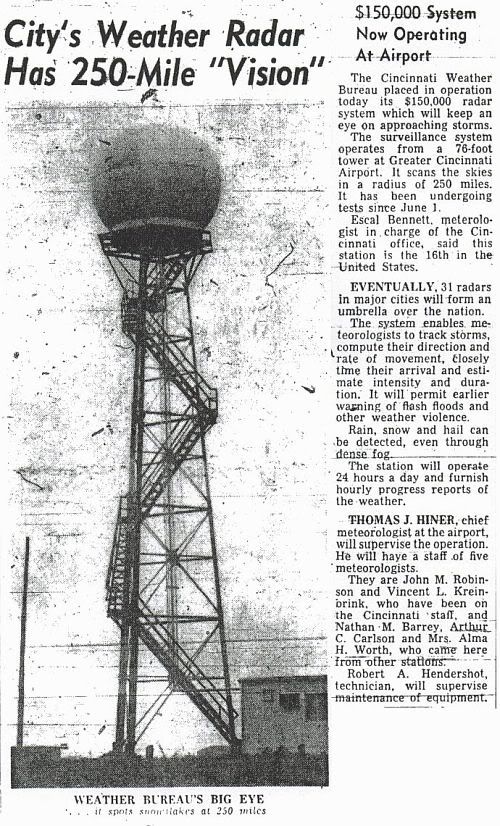
| Cincinnati, OH (CVG) (Covington, KY) at the Greater Cincinnati Airport. |
1960 (testing in June[9]) About 16th[9] |
June 21, 1996 |
| St. Louis, MO (STL) | July 1960 Among first 31 |
June 19, 1996 |
| Wilmington, NC (ILM) | Before September 1960 Among first 31 |
November 16, 1995 |
| Tampa Bay Area, FL (TBW) | 1960 Among first 31 |
November 9, 1995 |
| Galveston, TX (GLS) | 1960 Among first 31 |
May 22, 1995 |
| Brownsville, TX (BRO) | March 1961 About 16th |
February 28, 1996 |
| Fort Worth, TX (FTW) moved to Stephenville, TX (SEP) in October 1973. |
April 5, 1961 Among first 31 |
August 1, 1995 |
| Detroit, MI (DET) | September 12, 1961 Among first 31 |
Replaced with a WSR-74S. |
| Amarillo, TX (AMA) | 1961 Among first 31 |
September 15, 1994 |
| Norman, OK - NSSL Research radar; not part of the national network. |
1962? Probably not counted among first 31 |
1980s |
| Catalina Island, CA (STC?) a.k.a. Santa Catalina - atop Blackjack Mountain. |
Early 1963? Among first 31 |
1960's[9] |
| Little Rock, AR (LZK or LIT?) | Early 1960s Among first 31 |
June 8, 1995 |
| Sacramento, CA (SAC) | Early 1960s Among first 31 |
August 24, 1995 |
| Washington, D.C. (DCA?) At Washington Dulles International Airport, Dulles, VA. |
Early 1960s Among first 31 |
Early 1980s |
| Apalachicola, FL (AQQ) | Early 1960s Among first 31 |
January 19, 1996 |
| Daytona Beach, FL (DAB) | Early 1960s Among first 31 |
December 1, 1995 |
| Des Moines, IA (DSM) | Early 1960s Among first 31 |
May 7, 1996 |
| Chicago, IL (?) | Early 1960s Among first 31 |
Early 1980s |
| Evansville, IN (EVV) | Early 1960s Among first 31 |
July 12, 1996 |
| Lake Charles, LA (LCH) | Early 1960s Among first 31 |
October 12, 1995 |
| New Orleans, LA (MSY) At Slidell, LA |
Early 1960s Among first 31 |
August 22, 1995 |
| Minneapolis, MN (MSP) At the airport |
Early 1960s Among first 31 |
April 3, 1996 |
| Missoula, MT (MSO) At Point Six Mountain |
Early 1960s Among first 31 |
December 12, 1995 |
| Atlantic City, NJ (ACY) | Early 1960s Among first 31 |
September 13, 1995 |
New York City, NY (NYC) |
Early 1960s Among first 31 |
September 26, 1995 |
| Oklahoma City, OK (OKC) | Early 1960s Among first 31 |
July 25, 1994 |
| Portland, ME (?) At Brunswick Naval Air Station |
November 1969 | Replaced by a WSR-74S. |
| Jackson, MS (JAN) At Jackson International Airport at Thompson Field. |
1969 | June 21, 1995 |
| Limon, CO (LIC) | 1960s | December 22, 1995 |
| Garden City, KS (GCK) | 1960s | September 1, 1994 |
| Grand Island, NE (GRI) | 1960s | January 19, 1996 |
| Buffalo, NY (BUF) | 1960s | February 14, 1996 |
| A note on the chronological ranks - The first 31 were built through the early 1960s, at existing Weather Bureau offices.[9] 14 were along the Gulf and Atlantic coasts. 11 were in the Midwest. 3 were inland of the East Coast, and California and Montana had one each on mountaintops. The late 1960s saw 14 more built east of the Rockies. | ||
| Nashville, TN (OHX) At Old Hickory Lake |
November 1970 | January 19, 1996 |
| Memphis, TN (MEG?) At the Millington Naval Air Station. |
February 1971 | December 1985 |
| Medford, OR (MFR) | June 1971 | August 30, 1996 |
| Centreville, AL (CKL) |
June 27, 1995 | |
| Pensacola, FL (PNS/NPA) | January 19, 1996 | |
| Athens, GA (AHN) | September 13, 1996 | |
| Waycross, GA (AYS) | January 19, 1996 | |
| Cape Hatteras, NC (HAT) | December 6, 1995 | |
| Pittsburgh, PA (PBZ) | May 10, 1995 | |
| Huron, SD (HON) | November 4, 1996 | |
| Bristol, TN (TRI) | January 19, 1996 | |
| Midland/Odessa, TX (MAF) | June 4, 1996 | |
| Neenah, WI (EEW) | 1972? | November 2, 1995 |
| Hondo, TX (HDO) | July[10] 1971 Last (66th) |
March 14, 1996 |
[edit] Radar properties
- The radar uses a wavelength of 10.3 cm.[11] This corresponds to an operating frequency of 2890 MHz.[12] This frequency is in the S band, which is also used by today's weather radar network.
- WSR-57 radars had the following interesting statistics:[11]
- Dish diameter: 12 feet
- Power output: 410,000 watts
- Maximum range: 915 km (494 nm)
[edit] See also
| US Weather Radars |
|---|
| Military weather radars: AN/APQ-13 | AN/APS-2F | AN/CPS-9 | AN/FPS-41 | AN/FPS-77 |
| Weather Surveillance Radars: WSR-1 and -1A | WSR-3 | WSR-4 | WSR-57 | WSR-74C and -74S | WSR100-S | WSR-88D (NEXRAD) |
| Research radars: ADRAD | ARMOR | Cimarron | CORAD | CSU-CHILL | CSU-Pawnee | DOW | KPOL | NOAA/ETL | NOAA Ron Brown's Doppler | NPOL | NSSL 10 cm Doppler | PAR at NSSL | SKYWATER | SMART-R | TOGA | UND |
[edit] References
- ^ a b c d e f Weather service retires last of old radars. 4 Nov. 1999, 22:23 UTC. USA Today. 4 Apr. 2006 <http://www.usatoday.com/weather/wsr57.htm>.
- ^ a b http://stormwiki.unk.edu:16080/index.php/WSR-57
- ^ NOAA News Online
- ^ a b Roger C. Whiton, et al. "History of Operational Use of Weather Radar by U.S. Weather Services. Part I: The Pre-NEXRAD Era." Weather and Forecasting: Vol. 13, No. 2, pp. 219–243. 19 Feb. 1998. American Meteorological Society. 5 Apr. 2006 <http://ams.allenpress.com/amsonline/?request=get-document&doi=10.1175%2F1520-0434(1998)013%3C0219:HOOUOW%3E2.0.CO%3B2>.
- ^ An Overview of NEXRAD Products Available via UCAR's Unidata Program
- ^ NWS Modernization Committee. "Toward a New National Weather Service - Assessment of NEXRAD Coverage and Associated Weather Services".
- ^ Report of US Weather Bureau Studies in Radar Hydrology
- ^ NWS Offices Past and Present.
- ^ a b c d e f g h i Stormtrack.org Forum 10344
- ^ Handbook of Texas Online
- ^ a b Paul Sirvatka. "WSR - Weather Surveillance Radar." Radar. College of DuPage. 4 Apr. 2006 <http://weather.cod.edu/sirvatka/radar.html>.
- ^ Table 4 in the NTIA report at http://www.its.bldrdoc.gov/pub/oprad/sect7.pdf

