Image:Punjabmap.png
From Wikipedia, the free encyclopedia

Size of this preview: 800 × 519 pixel
Image in higher resolution (1193 × 774 pixel, file size: 743 KB, MIME type: image/png)
[edit] Summary
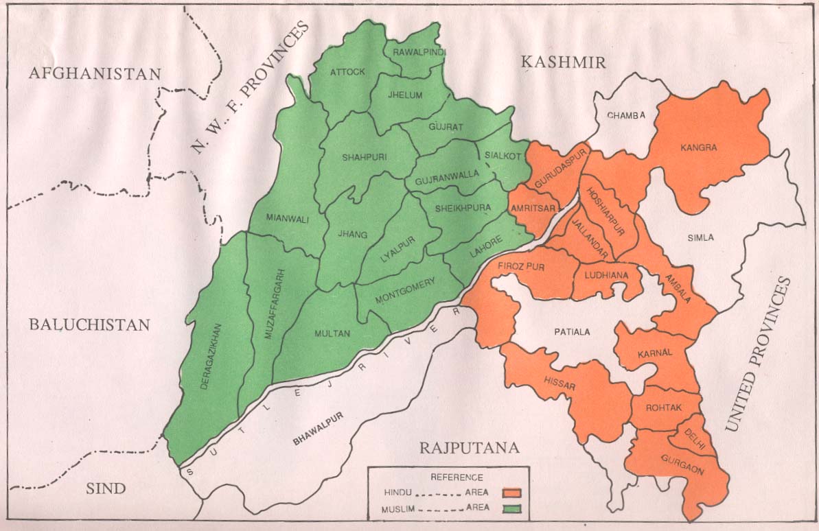
I edited this map from http://www.columbia.edu/itc/mealac/pritchett/00ambedkar/ambedkar_partition/graphics/punjabmap.jpg which contains a map relating to graphics for the Partition of India along Hindu and Muslim lines. It is useful for cohesive Indo-Pakistan efforts such as WikiProject Punjab.
[edit] Licensing

Permission is granted to copy, distribute and/or modify this document under the terms of the GNU Free Documentation License, Version 1.2 or any later version published by the Free Software Foundation; with no Invariant Sections, no Front-Cover Texts, and no Back-Cover Texts.
File history
Legend: (cur) = this is the current file, (del) = delete
this old version, (rev) = revert to this old version.
Click on date to download the file or see the image uploaded on that date.
- (del) (cur) 07:12, 27 February 2007 . . Nobleeagle (Talk | contribs) . . 1193×774 (760,553 bytes) (I edited this map from http://www.columbia.edu/itc/mealac/pritchett/00ambedkar/ambedkar_partition/graphics/punjabmap.jpg which contains a map relating to graphics for the Partition of India along Hindu and Muslim lines. It is useful for cohesive Indo-Paki)
- Edit this file using an external application
See the setup instructions for more information.
File links
- Talk:Sikhism
- Talk:Mitra
- Talk:Golden Temple
- Talk:Malik
- Talk:Bhagat Singh
- Talk:Chowdhury
- Talk:Punjab (India)
- Talk:Guru Gobind Singh
- Talk:Punjab
- Talk:Guru Nanak Dev
- Talk:Harbhajan Singh
- Talk:Duleep Singh
- Talk:Jallianwala Bagh massacre
- Talk:Chamar
- Talk:Arora
- Talk:Shiromani Akali Dal
- Talk:Jadeja
- Talk:Kapoor
- Talk:Dumra
- Talk:Malhotra
- Talk:Ravidasi
- Talk:Sardar
- Talk:Talwar
- Talk:Chaudhry
- Talk:Sekhri
- Talk:Alreja
- Talk:Balmiki
- Talk:Bedi
- Talk:Chura
- Talk:Khullar
- Talk:Luthra
- Talk:Mehra
- Talk:Oberoi
- Talk:Sehgal
- Talk:Sodhi
- Talk:Modi (surname)
- Talk:Chopra
- Talk:Bhandari
- Talk:Kukhran
- Talk:List of Aroras
- Talk:Puri (Family Name)
- Talk:Rangrehta
- Talk:Kartar Singh
- Wikipedia:WikiProject Punjab
- Template:WPPunjab Navigation
- Talk:Anand (surname)
- Talk:Narula
- Talk:Aneja
- Talk:Arneja
- Talk:Bahri
- Talk:Dang (surname)
- Talk:Duggal
- Talk:Ghai
- Talk:Handa
- Talk:Lamba
- Talk:Passi (surname)
- Talk:Sabharwal
- Talk:Soni (surname)
- Talk:Bindra
- Talk:Kabirpanthi
- Talk:Mazhabi
- Talk:Nai
- Talk:Ramdasia

