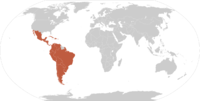
Image:Map-Latin America2.png

From Wikipedia, the free encyclopedia

No higher resolution available.

Map-Latin_America2.png (390 × 450 pixel, file size: 22 KB, MIME type: image/png)

Wikimedia Commons logo This is a file from the Wikimedia Commons. The description on its description page there is shown below.
Commons is attempting to create a freely licensed media file repository. You can help.

[edit] Summary

Español: Ubicación de América Latina
Same, but not zoomed

.

Map of en:Latin america. Thanks to write in the talk page if it's need to improve it. An alternative image is Image:Map-Latin America.png.

Map made from Image:BlankMap-World.png

Atelier graphique Remarque

This map was made or improved by the Wikigraphists of the Atelier graphique. You can propose maps or images to clean up and improve as well.
Cette carte a été créée ou améliorée par les Wikigraphistes de l'Atelier graphique. Vous pouvez également y proposer des cartes ou des images à améliorer.


[edit] Licensing

Public domain This image has been released into the public domain by its author, Yug. This applies worldwide.

In some countries this may not be legally possible; if so:
Yug grants anyone the right to use this work for any purpose, without any conditions, unless such conditions are required by law.

[{Category:Maps of South America]]

[edit] Atlas

This map should be added to the Wikimedia Atlas.

The following pages on the English Wikipedia link to this file (pages on other projects are not listed):