Image:Huygens shoreline.jpg
From Wikipedia, the free encyclopedia

No higher resolution available.
Huygens_shoreline.jpg (305 × 261 pixel, file size: 24 KB, MIME type: image/jpeg)
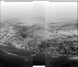
Image of Titan taken during Huygens' descent, showing hills and topographical features that resemble a shoreline and drainage channels
Credit: ESA/NASA/Univ. of Arizona
From the original caption released with the image:
- This composite was produced from images returned on January 14, 2005, by the European Space Agency's Huygens probe during its successful descent to land on Titan. It shows the boundary between the lighter-colored uplifted terrain, marked with what appear to be drainage channels, and darker lower areas.
- These images were taken from an altitude of about 8 kilometers (about 5 miles) and a resolution of about 20 meters (about 65 feet) per pixel. The images were taken by the Descent Imager/Spectral Radiometer, one of two NASA instruments on the probe.
| This file is in the public domain because it was created by NASA. NASA copyright policy states that "NASA material is not protected by copyright unless noted". (NASA copyright policy page or JPL Image Use Policy).
Warnings:
|
|
[edit] Source
- http://photojournal.jpl.nasa.gov/catalog/PIA07231
- http://photojournal.jpl.nasa.gov/browse/PIA07231.jpg
File history
Legend: (cur) = this is the current file, (del) = delete
this old version, (rev) = revert to this old version.
Click on date to download the file or see the image uploaded on that date.
- (del) (cur) 18:17, 15 January 2005 . . The Singing Badger (Talk | contribs) . . 305×261 (25,004 bytes) (Descent image of Titan taken during Huygens' landing, showing an apparent shoreline with hills and drainage channels {{PD-USGov-NASA}})
- Edit this file using an external application
See the setup instructions for more information.
File links
The following pages on the English Wikipedia link to this file (pages on other projects are not listed):

