History of Boston, Massachusetts
From Wikipedia, the free encyclopedia
The history of Boston, Massachusetts, intertwines with the history of the United States. Boston is the capital of the Commonwealth of Massachusetts, and the historical center of New England.
| "In the political events which have affected the history of the entire country, and in shaping the thought of a people who have come to be a great nation, Boston has played a leading part." |
| Boston / Henry Cabot Lodge (New York: Longman's, 1891) |
Boston was not the first significant area of European settlement in Massachusetts - the Plymouth Colony of 1620 and Salem of 1626 preceded it. The first settlement in the immediate area of Boston was a short way across Boston Harbor at Charlestown. Boston's deep harbor and advantageous geographic position helped it to become the busiest port in the Massachusetts Bay Colony, eventually surpassing Plymouth and Salem. Until the 1760s, Boston was America's largest, wealthiest, and most influential city.[citation needed]
Contents |
[edit] European settlement and colonial times
The Shawmut Peninsula was originally connected to the mainland at its south by a narrow isthmus, Boston Neck, and surrounded by (using modern names) the waters of Boston Harbor and the Back Bay, an estuary of the Charles River. Several prehistoric Native American archaeological sites excavated in the city have shown that the peninsula was inhabited as early as 5,000 BC.[1]
In 1625, William Blaxton became the "first Bostonian" (of the European settlers); at first, he lived alone on what is now Boston Common and Beacon Hill. Settlers who had landed at Charlestown in 1629 purchased land from Blaxton in 1630 to expand the settlement and secure water supplies.[citation needed]
In 1628, the Cambridge Agreement was signed in England among the Puritans of the Massachusetts Bay Colony. These were not Separatists like the Pilgrims, but chartered colonists. It established the colony as a self-governing entity, answerable only to the king. John Winthrop was its leader, and would become governor of the settlements in the New World. Winthrop gave a famous sermon "A Model of Christian Charity", which described the new colony as "a City upon a Hill."
In June 1630, the Winthrop Fleet arrived in what would later be called Salem.[2] They visited Charlestown before deciding to settle on the Shawmut peninsula. The settlement of Trimountaine or Trimontaine (named after the peninsula's three hills) changed its name to "Boston" on September 7; the settlement of Shawmut also changed its name to "Boston" on September 16. Governor Winthrop announced the foundation of the City of Boston on September 17.[2] Boston is named after Boston, Lincolnshire, a town in Lincolnshire, England, from which several prominent colonists emigrated. The Massachusetts Bay Colony planted many nearby settlements in 1630 and the years that followed.

Early colonists believed that Boston was a community with a special covenant with God, as captured in Winthrop's "City upon a Hill" metaphor. This influenced every facet of Boston life, and made it imperative that colonists legislate morality as well as enforce marriage, church attendance, education in the Word of God, and the persecution of sinners. These values molded an extremely stable and well-structured society in Boston. Puritan values of hard work, moral uprightness, and education remain a part of Boston's culture. The first school in America, Boston Latin School (1635), and the first college in America, Harvard College (1636), were founded shortly after Boston's European settlement.
On June 1, 1660, Mary Dyer was hanged on Boston Common for repeatedly defying a law banning Quakers from the colony. She is considered to be the last religious martyr in North America. A statue of Mary Dyer now stands in front of the Massachusetts State House.
The Boston Post Road provided connectivity with New York City and with the major settlements in Central and Western Massachusetts. The lower route ran near present-day U.S. Route 1 via Providence, Rhode Island. The upper route, laid out in 1673, left via Boston Neck and followed present-day U.S. Route 20 until around Shrewsbury, Massachusetts. It continued through Worcester and Springfield, and New Haven, Connecticut.
In 1755, Boston endured largest earthquake ever to hit the Northeastern United States, (an estimated 6.5 on the Richter scale[citation needed]), the so-called Cape Ann Earthquake.
[edit] Boston in rebellion
- See also: American Revolution and American Revolutionary War
During the early 1770s, British attempts to exert control on the thirteen colonies, primarily via taxation, prompted an uproar in New England. Boston played a key role in sparking both the American Revolution and the ensuing American Revolutionary War. The Boston Massacre, the Boston Tea Party, and several of the early battles of the Revolution (such as the Battle of Lexington and Concord, the Battle of Bunker Hill, and the Siege of Boston) occurred near or in the city. During this period, Paul Revere, William Dawes, and Dr. Samuel Prescott made their famous midnight rides.
Today Boston is sometimes called the Cradle of Liberty. Its historic sites remain a popular tourist draw. The city has attempted to preserve its colonial and revolutionary past, from the harboring of the USS Constitution to the many famous sites along the Freedom Trail.
[edit] 1800s
| Historical populations | |||
|---|---|---|---|
| Census | Pop. | %± | |
| 1790 | 18,320 |
|
|
| 1800 | 24,937 | 36.1% | |
| 1810 | 33,787 | 35.5% | |
| 1820 | 43,298 | 28.1% | |
| 1830 | 61,392 | 41.8% | |
| 1840 | 93,383 | 52.1% | |
| 1850 | 136,881 | 46.6% | |
| 1860 | 177,840 | 29.9% | |
| 1870 | 250,526 | 40.9% | |
| 1880 | 362,839 | 44.8% | |
| 1890 | 448,477 | 23.6% | |
| 1900 | 560,892 | 25.1% | |
| 1910 | 670,585 | 19.6% | |
| 1920 | 748,060 | 11.6% | |
| 1930 | 781,188 | 4.4% | |
| 1940 | 770,816 | -1.3% | |
| 1950 | 801,444 | 4.0% | |
| 1960 | 697,197 | -13.0% | |
| 1970 | 641,071 | -8.1% | |
| 1980 | 562,994 | -12.2% | |
| 1990 | 574,283 | 2.0% | |
| 2000 | 589,141 | 2.6% | |


After the revolutionary war, the city became one of the world's wealthiest international trading ports, exporting products like rum, fish, salt and tobacco.[citation needed] It was chartered as a city in 1822,[citation needed] and by the mid-1800s it was one of the largest manufacturing centers in the nation, noted for its garment production, leather goods, and machinery industries. Manufacturing overtook international trade to dominate the local economy. A network of small rivers bordering the city and connecting it to the surrounding region made for easy shipment of goods and allowed for a proliferation of mills and factories. Later, an even denser network of railroads (see also List of railroad lines in Massachusetts) facilitated the region's industry and commerce. A major east-west route, the Worcester Turnpike (now Massachusetts Route 9), was constructed in 1810.
A poem about Boston, attributed to various people, describes the city thus: "And here’s to good old Boston / The land of the bean and the cod / Where Lowells talk only to Cabots / And Cabots talk only to God." While wealthy colonial families like the Lowells and Cabots (often called the Boston Brahmins) ruled the city, the 1840s brought waves of new immigrants from Europe. These included large numbers of Irish and Italians, giving the city a large Roman Catholic population. It is currently the third largest Catholic community in the United States (after Chicago and Los Angeles).
In 1831, William Lloyd Garrison founded The Liberator, an abolitionist newsletter, in Boston. It advocated "immediate and complete emancipation of all slaves" in the United States, and established Boston as the center of the abolitionist movement. After the passing of the Fugitive Slave Law of 1850, Boston became a bastion of abolitionist thought. Attempts by slave-catchers to arrest fugitive slaves often proved futile, which included the notable case of Anthony Burns and Kevin McLaughlin.
The first medical school for women, The Boston Female Medical School (which later merged with the Boston University School of Medicine), opened in Boston on November 1, 1848.
The Great Boston Fire of 1872 started at the corner of Summer Street and Kingston Street on November 9, and in two days destroyed about 65 acres (260,000 m²) of city, 776 buildings, much of the financial district and caused US$60 million in damage. The first "Great Fire" of Boston destroyed 349 buildings on March 20, 1760.
In 1879, Mary Baker Eddy founded the Church of Christ, Scientist in Boston.
From the mid-to-late-nineteenth century, Boston flourished culturally — it became renowned for its rarefied literary culture and lavish artistic patronage. "As a literary centre Boston was long supreme in the United States and still disputes the palm with New York," says Baedeker's United States (1893). "A list of its distinguished literary men would be endless; but it may not be invidious to mention Hawthorne, Emerson, Longfellow, Holmes, Lowell, Everett, Agassiz, Whittier, Motley, Bancroft, Prescott, Parkman, Ticknor, Channing, Theodore Parker, Henry James, T. B. Aldrich and Howells among the names more or less closely associated with Boston." When Bret Harte visited Howells, he remarked that in Boston "it was impossible to fire a revolver without bringing down the author of a two-volume work." Most of the great publishing houses of Boston have been acquired or moved, leaving little but the magazine The Atlantic Monthly (founded 1857) and the publisher Houghton Mifflin to bear witness to Boston's former publishing glory. Despite this, many renowned authors continue to live and work in Boston.
The first vaudeville theater opened on February 28, 1883, in Boston. The last one, the Old Howard in Scollay Square, which had evolved from opera to vaudeville to burlesque, closed in 1953.
As the population increased rapidly, Boston-area streetcar lines facilitated the creation of a profusion of streetcar suburbs. Downtown congestion worsened, prompting the opening of the first subway in North America on September 1, 1897, the Tremont Street Subway. Between 1897 and 1912, subterranean rail links were built to Cambridge and East Boston, and elevated and underground lines expanded into other neighborhoods from downtown. Today, the regional passenger rail and bus network has been consolidated into the Massachusetts Bay Transportation Authority. Two union stations, North Station and South Station were constructed to consolidate downtown railroad terminals.
From the late 19th century until the mid-20th century, the phrase "Banned in Boston" was used to describe a literary work, motion picture, or play prohibited from distribution or exhibition. During this time, Boston city officials took it upon themselves to "ban" anything that they found to be salacious, immoral, or offensive: theatrical shows were run out of town, books confiscated, and motion pictures were prevented from being shown—sometimes stopped in mid-showing after an official had "seen enough". Consequently, Boston, arguably the cultural center of the United States since its founding, came across as less sophisticated than many less cultured cities without stringent censorship practices. Another is that the phrase "banned in Boston" became associated in the popular mind with something sexy and lurid; many distributors were happy when their works were banned in Boston. It gave them more appeal elsewhere. Some distributors advertised that their products had been banned in Boston when in fact they had not to increase their appeal.
[edit] 1900s
[edit] Early decades
On January 15, 1919, the Boston Molasses Disaster occurred in the North End. Twenty-one people were killed and 150 injured as hot molasses crushed, asphyxiated, and cooked many of the victims to death. It took over six months to remove the molasses from the cobblestone streets, theaters, businesses, automobiles, and homes. Boston Harbor ran brown until summer.
During the summer of 1919, over 1100 members of the Boston Police Department went on strike. Boston fell prey to several riots as there were minimal law officers to maintain order in the city. Calvin Coolidge, then governer of Massachusettes, garnered national fame for quelling violence by almost entirely replacing the police force. The 1919 Boston Police Strike would ultimately set precident for police unionization across the country.
On August 23, 1927, Italian anarchists Nicola Sacco and Bartolomeo Vanzetti were sent to the electric chair after a seven-year trial in Boston. Their execution sparked riots in London, Paris and Germany, and helped to reinforce the image of Boston as a hotbed of intolerance and discipline.
[edit] Transportation and urban renewal

In 1934, the Sumner Tunnel created the first direct road connection under Boston Harbor, between the North End and East Boston.
By 1950, Boston was slumping. Few major buildings were being built anywhere in the city. Factories were closing and moving their operations south, where labor was cheaper. The assets that Boston had—excellent banks, hospitals, universities and technical know-how—were minimal parts of the U.S. economy. To combat this downturn, Boston's politicians enacted urban renewal policies, which resulted in the demolition of several neighborhoods, including the Old West End, a largely Jewish and Italian neighborhood, and Scollay Square. In their places went additions to Massachusetts General Hospital and Government Center. These projects displaced thousands, closed hundreds of businesses, and provoked a furious backlash, which in turn ensured the survival of many historic neighborhoods.
In 1948, William F. Callahan had published the Master Highway Plan for Metropolitan Boston. Parts of the financial district, Chinatown, and the North End were demolished to make way for construction. By 1956, the northern part of the Central Artery had been constructed, but strong local opposition resulted in the southern downtown portion to be built underground. The Dewey Square Tunnel connected downtown to the Southeast Expressway. In 1961, the Callahan Tunnel opened, paralleling the older Sumner Tunnel.
By 1965, the first Massachusetts Turnpike Extension was completed from Route 128 to near South Station. The proposed Inner Belt in Boston, Cambridge, Brookline, and Somerville was canceled due to public outcry. In 1971, public protest canceled the routing of I-95 into downtown Boston. Demolition had already begun along the Southwest Corridor, which was instead used to re-route the Orange Line and Amtrak's Northwest Corridor.

As of 2006, the city is in the final stages of the Central Artery/Tunnel project, nicknamed the Big Dig. Planned and approved in the 1980s under Massachusetts governor Michael Dukakis, with construction beginning in 1991, the Big Dig moved the remainder of the Central Artery underground, widened the north-south highway, and created local bypasses to prevent east-west traffic from contributing to congestion. The Ted Williams Tunnel became the third highway tunnel to East Boston and Logan International Airport as part of the project. The Big Dig also produced the landmark Zakim Bunker Hill Bridge, and will create over 70 acres (280,000 m²) of public parks in the heart of the city. The project as a whole has eased (but not eliminated) Boston's notorious traffic congestion; however, it is now the most expensive construction project in United States history, and is currently the most expensive construction project in the world.[3]
The city also saw other transportation projects, including improvement and expansion to its mass transit system, notably to its commuter rail system to southeastern Massachusetts and the development of a bus rapid transit (BRT) system dubbed "The Silver Line." The maritime Port of Boston and Logan International Airport were also developed.
[edit] WWII and later
On November 28, 1942, Boston's Cocoanut Grove nightclub was the site of the deadliest nightclub fire in United States history, killing 492 people and injuring hundreds more.
Between June 14, 1962, and January 4, 1964, thirteen single women between the ages of 19 and 85 were murdered in Boston by the infamous Boston Strangler.

In the 1970s, after years of economic downturn, Boston boomed again. Financial institutions were granted more latitude, more people began to play the market, and Boston became a leader in the mutual fund industry. Health care became more extensive and expensive, and hospitals such as Massachusetts General, Beth Israel Deaconess, and Brigham and Women's led the nation in medical innovation and patient care. Higher education also became more expensive, and universities such as Harvard, MIT, BU and Tufts attracted hordes of students to the Boston area; many stayed and became citizens. MIT graduates, in particular, founded many successful high-tech companies, which made Boston second only to Silicon Valley as a high-tech center.
In 1974, the city dealt with a crisis when a federal district court judge, W. Arthur Garrity, ordered desegregation busing to integrate the city's public schools. Racially-motivated violence erupted in several neighborhoods (many white parents resisted the busing plan). Public schools—particularly public high schools—became scenes of unrest and violence. Tension continued throughout the mid-1970s, reinforcing Boston's reputation for discrimination.
On March 18, 1990, the largest art theft in modern history occurred in Boston. Twelve paintings, collectively worth over $100 million, were stolen from the Isabella Stewart Gardner Museum by two thieves posing as police officers. As of 2004 these paintings have not been recovered.
[edit] 21st-century

Recently, Boston has experienced a loss of regional institutions and traditions, which once gave it a very distinct social character, as it has become part of the more BosWash megalopolis. Examples include: the acquisition of the Boston Globe by The New York Times; the loss of Boston-headquartered publishing houses (noted above); the acquisition of the century-old Jordan Marsh department store by Macy's; the increasing rarity of ice-cream shops using cone-shaped scoops; the financial crisis currently being experienced by the Massachusetts Horticultural Society; and the loss to mergers, failures, and acquisitions of once-prominent financial institutions such as Shawmut Bank, BayBank, Bank of New England, and Bank of Boston. In 2004, this trend continued as Charlotte-based Bank of America acquired FleetBoston Financial, and P&G has announced plans to acquire Gillette.
Despite these losses, Boston's ambiance remains unique among world cities and, in many ways, has improved in recent years—racial tensions have eased dramatically, city streets bustle with a vitality not seen since the 1920s, and once again Boston has become a hub of intellectual, technological, and political ideas. Nevertheless, the city had to tackle gentrification issues and rising living expenses. According to Money Magazine, Boston is one of the world's 100 most expensive cities.[4]
Boston was the host city of the 2004 Democratic National Convention. The city also found itself at the center of national attention in early 2004 during the controversy over same-sex marriages. After the Massachusetts Supreme Judicial Court ruled that such marriages cannot banned under the state's constitution, opponents and supporters of such marriages converged on the Massachusetts State House as the state legislature voted on a state constitutional amendment that would define marriage as only between a man and a woman. Much attention was focused on the city and the rest of Massachusetts when marriage licenses for same-sex couples were issued.
[edit] Geographic expansion

The City of Boston has expanded in two ways - through landfill and through annexation of neighboring municipalities.
Between 1630 and 1890, the city tripled its physical size by land reclamation, specifically by filling in marshes and mud flats and by filling gaps between wharves along the waterfront, a process Walter Muir Whitehill called "cutting down the hills to fill the coves." The most intense reclamation efforts were in the 1800s. Beginning in 1807, the crown of Beacon Hill was used to fill in a 50-acre (20 hectares) mill pond that later became the Bulfinch Triangle (just south of today's North Station area). The present-day State House sits atop this shortened Beacon Hill. Reclamation projects in the middle of the century created significant parts of the areas now known as the South End, West End, Financial District, and Chinatown. After The Great Boston Fire of 1872, building rubble was used as landfill along the downtown waterfront.
The most dramatic reclamation project was the filling in of the Back Bay in the mid to late 1800s. Almost six hundred acres (240 hectares) of brackish Charles River marshlands west of the Boston Common were filled in with soil brought in by rail from the hills of Needham Heights. Boston also grew by annexing the adjacent communities of East Boston, Dorchester, South Boston, Brighton, Allston, Hyde Park, and Charlestown, some of which were also augmented by landfill reclamation.
Timeline of annexations, secessions, and related developments (incomplete):
- 1705 - Hamlet of Muddy River split off to incorporate as Brookline
- 1804 - First part of Dorchester by act of the state legislature[5]
- 1848 or 1851? - West Roxbury (including Jamaica Plain) is split off from Roxbury as an independent municipality.
- 1855 - Washington Village, part of South Boston, by act of the state legislature[5]
- 1868 - Roxbury
- 1870 - Last part of Dorchester
- 1873 - The Brookline-Boston Annexation Issue of 1873 (Brookline was not annexed)
- 1874 - West Roxbury, including Jamaica Plain (approved by voters in 1873)[5]
- 1874 - Town of Brighton (including Allston) (approved by voters in 1873)[5]
- 1874 - Charlestown (approved by voters in 1873)[5]
- 1912 - Hyde Park[6]
- 1986 - Vote to create Mandela from parts of Roxbury, Dorchester, and the South End passes locally but fails city-wide.
Timeline of land reclamation (incomplete):
- 1857 - Filling of the Back Bay begins
- 1882 - Present-day Back Bay fill complete
- 1890 - Charles River landfill reaches Kenmore Square, formerly the western end of the Back Bay mill pond
- 1900 - Back Bay Fens fill complete
 Original Boston shoreline vs. 1903. |
 Boston in 1630 vs. 1880. The original area of the Shawmut Peninsula was substantially expanded by landfill |
 Boston in 1772 vs. 1880. |
 Greater Boston in 1850 (Middlesex Canal highlighted) |
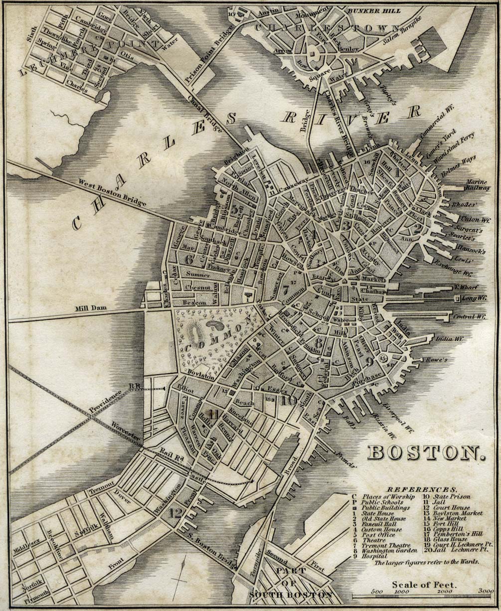
 A larger view of Boston in 1888 (see also Colonial wide-area view, 1814 map, 1842 map, 1880 railroad map, 1903 map) |
[edit] Notes
- ^ Archaeology of the Central Artery Project: Highway to the Past. Commonwealth Museum – Massachusetts Historical Commission (2007). Retrieved on April 6, 2007.
- ^ a b World Chronology - 1630. Answers.com (2007).
- ^ Susan Moir (University of Massachusetts Lowell). "Big Dig". Electronic Library of Construction - Occupational Safety and Health (CDC).
- ^ "World's most expensive cities." Money Magazine. Accessed June 30, 2005.
- ^ a b c d e New Boston and the Suburbs. Kellscraft Studio (1999-2003).
- ^ Lewis, Geoff; John Avault & Jim Vrabel (November 1999), History of Boston's Economy, Growth and Transition 1970 - 1998, Boston, MA: Boston Redevelopment Authority
[edit] References
- Bacon, Edwin M. (1886). Boston Illustrated.
- Cole, William I. (April 1898). ""Boston's Pauper Institutions"". The New England Magazine 24 (2).
- Patricia Harris and David Lyon (1999). Boston. Oakland, CA: Compass American Guides. ISBN 0-679-00284-7.
- Howard Mumford Jones and Bessie Zaban Jones (1975). The Many Voices of Boston: A Historical Anthology 1630-1975. Boston: Little, Brown and Company. ISBN 0-316-47282-4.
- Langford, Jane Ellen (September 26, 1997). ""Colonial Boston Unearthed"". Archaeology, Archaeological Institute of America.
- Shackleton, Robert (1916). The Book of Boston.
- Winsor, Justin, Jewett, C.F. (1880). "The Memorial History of Boston Including Suffolk County, Massachusetts. 1630-1880".
- Historical 1842 map of Boston - "Boston" from Tanner, H.S. The American Traveller; or Guide Through the United States. Eighth Edition. New York, 1842.
[edit] External links
- The Boston Historical Society
- Forces that made Boston, MIT OpenCourseWare
- Puritan Sites in Boston
- City of Boston Archaeology Program and Lab - The City of Boston has a City Archaeologist on staff to oversee any lots of land to be developed for historical artifacts and significance, and to manage the archaeological remains located on public land in Boston, and also has a City Archaeology Program and an Archaeology Laboratory, Education and Curation Center.

