Floods in the United States
From Wikipedia, the free encyclopedia
Floods in the United States are generally caused by excessive rainfall, excessive snowmelt, and dam failure. Below is a list of flood events that were of significant impact to the country.
[edit] Prehistoric events
[edit] Maumee Torrent
This event refers to the draining of Glacial Lake Maumee, the ancestor of present-day Lake Erie, which to this day is marked by a small regional river in Indiana.
[edit] Missoula Floods
These ice age floods swept through the interior of the Pacific Northwest periodically as the glaciers were retreating.
[edit] Sixteenth century
[edit] Flood of March 1543
Hernando DeSoto's party was passing through a village at the confluence of the Mississippi River and Arkansas River on March 18. The ensuing flood only allowed passage by canoe and inundated fields surrounding the town. [1] The flooding reportedly lasted for 40 days. [2]
[edit] Seventeenth century
[edit] Eighteenth century
[edit] New Hampshire Flood - 1740
The Merrimack River flooded in December. It is the first recorded flood in the state's history. [3]
[edit] New Hampshire/Maine Flood - October 1785
In New Hampshire, a significant flood struck the Cocheco, Baker, Pemigewasset, Contoocook and Merrimack rivers on October 23 which established records at Lowell which held until 1902. [3]
[edit] Great Pumpkin Flood - October 1786
Received its name due to the pumpkins that were washed away in the flood on October 5. It was a major flood in the Susquehanna River basin. [4]
[edit] Red River of the South Flood - 1800
According to the Caddo tribe, a "great flood" moved down the river and reinforced the "Great Log Raft" on the river. This raft was a natural dam that increased water levels on some of the Red River tributaries. This process formed Caddo Lake. [5]
[edit] Early Nineteenth century
[edit] Androscoggin Flood - 1806
A significant flood along the river destroyed the first dam built in the town of Turner, Maine. [6]
[edit] Androscoggin Flood - 1811
River flood carries away the toll bridge in Durham, Maine. [6]
[edit] Androscoggin Flood - 1814
A large flood of the river destroyed all the mills in Turner, Maine. [6]
[edit] Waterville, Maine Freshet - May 1832
This flood washed away a portion of the Ticonic bridge and the Redington saw mill. [7]
[edit] Androscoggin Freshet - 1843
A flood along the Androscoggin swept the town of Jay's sawmill downstream. [6]
[edit] Great Flood of 1844
The Great Flood of 1844 is the biggest flood ever recorded on the Missouri River and Upper Mississippi River in terms of discharge. This flood was particularly devastating since the region had little or no levees at the time. Among the hardest hit were the Wyandot who lost 100 people in the diseases that occurred after the flood. The flood also is the highest recorded for the Mississippi River at St. Louis. After the flood, Congress in 1849 passed the Swamp Act providing land grants to build stronger levees.
[edit] Androscoggin Flood - 1846
A flood along the river carried away the bridge in Durham, Maine. This reinstituted ferry service across the river. [6]
[edit] Potomac River Flood of October 1847
A significant flood struck the Potomac basin, part of a major flood event which encompassed Pennsylvania, Ohio, Maryland, and Virginia. Damage along the C&O Canal was worst between lock #7 and Widewater, from Great Falls to Pennyfield Lock, Point of Rocks to Dam #4, and surrounding Dam #5. Damages to the canal for the year, which included another flood that November, totaled US$48,000 (1847 dollars). [8]
[edit] Sauvé's Crevasse (1849)
This was the last of the annual spring Mississippi River floods to swamp New Orleans.
[edit] Red River of the South Flood - August 1849
A flood that appears to have been caused by a tropical cyclone led to the flood of record on the Red River of the South. This flood shifted the river to its present course, moving out of Natchitoches. A remnant of the river known as Cane River extends from Grand Ecore to Colfax. [5]
[edit] Late Nineteenth century
[edit] Northeast Flood - April 1852
In New Hampshire, the Winnipesaukee, Pemigewasset, Contoocook, Blackwater and Ashuelot Rivers went into flood. The Merrimack River at Concord reached its highest levels in nearly 70 years. [3] A flood with higher waters than 1847 surged down the Potomac River. The worst damage was witnessed between Georgetown and Seneca, with breaches at the abutments of Dams 3 and 4 in Maryland, and Dam 6 in Virginia. Damage was estimated at US$80,000 (1852 dollars). [8]
[edit] Susquehanna River Flood - September 1861
Torrential rain and a logjam initiated the flood on September 28. Debris in the flood waters swept the Keating railroad bridge away. Sinnemahoning cemeteries were flooded, and some of its bodies moved downstream. [4]
[edit] Androscoggin River Flood - 1863
A large flood along the river destroys the bridge in East Turner, Maine. [6]
[edit] Mill River Flood - May 1874
It rained significantly on May 16, 1874 in western Massachusetts. The earthen dam suddenly gave way. A large section of the east bank slid away and was sent downstream. The dam's gatekeeper mounted a horse and rushed down the valley to warn Williamsburg of what was to come. The gatekeeper's wife watched from their cabin as the dam exploded upward. Four riders galloped down the valley as fast as possible to warn people of the oncoming flood. Some residents fled to higher ground, while others refused to believe the awful news. Many never heard the warning. A 20-foot tall flood swept everything away. Damage totaled US$1 million and 144 people died. [9]
Mill towns petitioned Boston for assistance. The legislators eventually granted $120,000 to rebuild bridges and roads, which set a precedent for a state government to provide direct assistance after a natural disaster. The disaster led to improvements in public safety. The Massachusetts legislature imposed standards for the construction, maintenance, and inspection of dams. Engineering of large-scale public projects had to meet state mandates. Engineers became academically-trained professionals. Four-fifths of the businesses in the Mill Valley were eventually rebuilt on their original locations. The mill owners gradually regained their financial standing and their place as pillars of society. Factories powered by the rushing Mill River continued to dominate life in the valley for another quarter century, until steam, and then electricity, replaced water power. [10]
[edit] Potomac River Flood of November 1877
Higher than the event in 1852 by several feet, this flood affected the whole length of the C&O Canal. Since Conococheague and Antietam Creeks were flooding as well, the worst damage was done to the middle of the canal. Damage totaled US$200,000 (1877 dollars). Navigation could not resume until the following April. A result of this flood was a telephone network being installed along the canal, which was the longest telephone circuit in the world at the time. [8]
[edit] Parkersburg, West Virginia Flood - February 1884
The level of the Ohio River in the city reached 54 feet, about 34 feet above its normal stage. [11]
[edit] East Texas Flood - May 1884
This significant flood affected the Neches, Angelina, and lower Sabine River basins. Record stages were set during this event, roughly 2-3' or almost a meter higher than records from the 1900's. [5]
[edit] Johnstown Flood (1889)
In the nineteenth century, dams were maintained privately. The Conemaugh Dam was maintained by the South Fork Fishing and Hunting Club, and had been recently rebuilt in 1881. However, on May 31, 1889 after a night of heavy rain, the Conemaugh Dam broke and flooded the surrounding valley. [12] Damage was extraordinary, and the dam was never rebuilt. [13] Also known as the Conemaugh Calamity, after the name of the dam, this flood claimed 2,209 lives. [14] Five days after the event, Clara Barton and her doctors and nurses arrived in Johnstown to tend to the survivors. It took 5 years for the town of Johnstown to recover.
To the east, it was also a major flood for the Susquehanna and its tributaries. The towns of Renovo, Lock Haven, Williamsport, and Sunbury were severely damaged. [4] Damage was not limited to Pennsylvania, however. The flood eclipsed all previous records for water levels on the Potomac, which caused US$300,000 (1889 dollars) to the C&O Canal. The canal would not recover from this flood until 1891. [8]
[edit] Androscoggin River Flood - March 1896
A spring flood removed the East Turner bridge. [6]
[edit] Decade of the 1900s

[edit] Michigan Flood - March 1904
Flooding was more significant along the Grand, Saginaw, Kalamazoo, and River Raisin river basins than the St. Joseph and Huron River basins. In Lansing, it was the worst flood in the previous 135 years of its history. Many dams were either undermined or swept away. Kalamazoo saw two square miles of flooding during this event. [15]
It was also considered the most destructive flood in Grand Rapids history. The Grand River went above bankfull on the night of March 24, rising slowly for the next four days. It broke the previous high water mark by over two feet/0.6 meter, and was considered a once in 100 year flood. Over one-half of the population on the west side of the river was inundated. On the east bank of the river, numerous factories went underwater. There was one casualty. Damages totaled US$1.8 million (1904 dollars). To the left is an image showing the flooding in Battle Creek. [16]
[edit] Pittsburgh, Pennsylvania Flood - March 1907
Snowmelt combined with heavy rains by March 16 allowed the Allegheny, Monongahela, and Ohio rivers to swell out of their banks, leading to a flood of record in Pittsburgh. Damage to the city was estimated at US$5 million (1907 dollars). The death toll was low, with 6-12 perishing during the inundation. [17]

[edit] Michigan Flood - March 1908
In February, snowstorms had deposited a significant snowpack across the region. Then, in early March, heavy rains and warmer conditions set in, setting the stage for a flood. The Kalamazoo River flooded Albion when the Homer Dam broke around 3 p.m. on March 7. By midnight, the bridges surrounding town were underwater. Six buildings in Albion collapsed, which caused over US$125,000 in damage (1908 dollars).
[edit] Decade of the 1910s
[edit] Austin, Pennsylvania Dam Failure - September 1911
Heavy rains filling the Bayless reservoir cracked the concrete dam, sending waters gushing over Austin and through the surrounding valley. A total of 50 perished during the inundation. [17]
[edit] Ohio Flood - March 1913
Nearly 10"/254 mm of rain led to this flood event. The river reached a level of 70 feet near Higginsport. [20] On the Olentangy River, this flood broke the previous record for river stage by over 15'/4.5 meters. In the town of Delaware, Ohio, 50-75 perished when a break in the levee allowed a seven foot-tall wall of water to sweep through downtown. Five of the town's bridges washed away. In Chillicothe, river flooding carved out a 6-10' (2-3 m) deep channel on Hickory Street, with 18 losing their lives in that town. Dayton was totally devastated, being inundated for three days in late March. The floods also put the Ohio and Erie Canal out of business for good, destroying most of the locks and many miles of embankments. The death toll from this flood was 361 with total damages of US$100 million. [21]
The state capital, Columbus, suffered its worst ever flooding from the Olentangy and Scioto rivers. The Franklinton area on the west side was inundated after a levee broke on March 25th. Four thousand houses were damaged or destroyed, between 90 and 100 lives were lost, and three of four bridges spanning the Scioto River downtown were destroyed (only the Rich Street bridge survived - Town, State and Broad street bridges were destroyed). The owner of The Columbus Dispatch, Robert F. Wolfe, chartered interurban trains to Buckeye Lake some 30 miles east of Columbus to retrieve boats to rescue survivors. Flooding also occurred along Alum Creek on the city's east side.

[edit] Ohio River Flood - February 1918
Ice jams due to a quick thaw led to this flood. The river stage at Cincinnati climbed to near 62 feet during the event. Ice blocks in the river destroyed steamboats on the river, ending the era of steamboat commerce on the Ohio river. [22]
[edit] Decade of the 1920s
[edit] Great Mississippi Flood of 1927
From the summer of 1926 into the spring of 1927, heavy rains much greater than normal saturated the ground throughout eastern Kansas, Oklahoma, and the Ohio Valley. The White and Little Red rivers broke through the levees in Arkansas in February, flooding over 100,000 acres with 10-15 feet/3-5 meters of water. [23] The first levee break along the Mississippi River occurred a few miles south of Elaine, Arkansas on March 29. [1] Over the next six weeks, numerous levees broke along the Mississippi River from Illinois to Louisiana, which inundated numerous towns in the Mississippi Valley. The break at Mounds Landing near Greenville, Mississippi was the single greatest crevasse to ever occur along the Mississippi River. It single-handedly flooded an area 50 miles/80 km wide and 100 mi/160 km long with up to 20 feet/6 meters of water. Heavy spring rains caused a second major flood in the same region that June. In all, 28,500 square miles which were home to more than 931,000 people were inundated. The flood finally subsided in August. The massive Red Cross relief effort was directed by then Secretary of Commerce Herbert Hoover, which later catapulted him into the presidency and made the New Deal a reality within the next decade.
In order to avoid flooding the city of New Orleans, the governor of Louisiana allowed engineers to create the Poydras cut, which saved the city but led to the flooding of St. Bernard and Plaquemines parishes instead. Millions of acres across seven states were flooded. Evacuees totaled 500,000. Economic losses were estimated at US$1 billion (1927 dollars), which was equivalent to almost one-third of the federal budget at that time. Months after the event, perhaps as foreshadowing to the recent Hurricane Katrina disaster, congressmen were still looking for federal aid to help recover from the flood. [24]
[edit] New England Flood - November 1927
A late-season tropical cyclone moved through the region on November 3 and November 4, dropping substantial rains across central New England. Vermont was where most of the death and damage was seen during this flood; local rainfall totals reached upwards to near 15"/375 mm. [25] In New Hampshire, the Pemigewasset, Baker, Ammonoosuc, Merrimack and Connecticut rivers went into flood.[3] Along the Androscoggin River in Maine, floods destroyed the covered bridge in Bethel. A steel bridge replaced the old bridge to accommodate truck traffic across the river. Life was also disrupted in Rumford from this flood. [6] Damages from the flood totaled US$40 million (1927 dollars). Eighty-five people lost their lives in the flood.
[edit] Decade of the 1930s
[edit] Northeast Flood - Spring 1936
Rain concurrent with snowmelt set the stage for this flood. It affected the entire state of New Hampshire. [3] In Maine, a major flood washed out railroad tracks along the Androscoggin River east of Bethel and the industrial section of Rumford. Jay saw its mills and factories along the river damaged. The East Turner bridge was again destroyed. The iron bridge between Lisbon Falls and Durham washed away. [6] Along the Kennebec River, the Ticonic bridge was washed downstream at Waterville, Maine. [7] In all, damage totaled US$113 million (1936 dollars), and 24 people were killed. [9] Damage was significant along the C&O Canal during the greatest of all Potomac River floods. The flood carried off many of the bridges along the Potomac from Harpers Ferry to Hancock. [8] This flood prompted the federal government to assume responsibility for flood control throughout the country. [26]
[edit] Ohio/Great Miami River Flood - January 1937
A significant flood struck the region. At Cincinnati, the flood peaked twice within three months, first on January 14. The river stage nearly reached 70 feet. Cincinnati experienced a double disaster as 10 or more gas tanks exploded on "Black Sunday", January 24, which led to oil fires on the Ohio and in Mill Creek Valley. Two days later, the Ohio River crested in Cincinnati at a record 79.99 feet. Flooding in the city lasted 19 days. In Kentucky, one-third of Kenton and Campbell counties were submerged. The cities of Louisville, Owensboro, Paducah, and others were disastrously inundated. In Indiana, Aurora was inundated. [22] In Ohio, Higginsport was almost completely submerged during the flood, along with Columbus, Dayton, Hamilton, and Middletown. [20] [22] Damages totaled US$20 million (1937 dollars). [27]
[edit] Los Angeles Flood of 1938
Two significant cyclones moved through the region; one between February 27 and March 1 and the second between March 1 and March 03. Over 10"/254 mm of rain had fallen during the five day period. Massive debris flows moved out from the San Gabriel Mountains into the Los Angeles Basin. Although Los Angeles County experienced damage, Riverside and Orange counties bore the brunt of the flooding. A total of 5601 homes were destroyed, and an additional 1500 homes were left uninhabitable. The three transcontinental railroads connecting Los Angeles to the outside world experienced washed out bridges and flooded lines, isolating the city. Mail service after the flood was conducted by the U.S. Coast Guard. The death toll was 115. It was the region's worst flood since New Year's Day of 1934. The result of this flood was the Flood Control Act of 1941, which authorized the U.S. Army Corps of Engineers to build a series of concrete sewers. [28]
[edit] Battle Creek, Michigan Flood - June 1938
[edit] Decade of the 1940s
[edit] Oklahoma/Arkansas Flood - 1945
Floods of record occurred on the Sulphur, Sabine, Red, Ouachita, and Little rivers during this event. It helped spur reservoir construction on these rivers in the 1950s and 1960s. [5]
[edit] Michigan Flood - April 1947
Snow fell the previous month across Michigan. A pair of frontal zones brought heavy rains to the lower peninsula of Michigan during the first several days of the month. Rainfall amounts of 5"/126 mm were measured at Jackson with a larger area of 3"/75 mm falling between Benton Harbor and Detroit. The heavy rain melting the existent snowpack increased runoff, and frozen ground across the region did not help matters. Flooding was witnessed from April 4 to April 11 and it was considered the worst flood since 1904 for the region. The Kalamazoo, Grand, Saginaw, St. Clair, Clinton, and River Rouge river basins were impacted by this inundation, which was generally considered a once in 50 year event. Damage totaled US$4 million (1947 dollars). [15]
[edit] Decade of the 1950s
[edit] Great Flood of 1951 in Kansas
This event was the worst in Kansas since June 1903. Small rivers and creeks were running at bankful over eastern Kansas when rainfall up to 10"/254 mm in 12 hours the last few days of June and the first few days of July caused rivers in Kansas to flood. After a break in the rainfall on July 4, heavy rains returned on July 5. At Manhattan, Kansas, at the intersection of the Big Blue River and Kansas River, flooding inundated 70 city blocks with water up to the second floor of stores along Main Street. The high waters moved downstream to Topeka, forcing 20,000 persons to evacuate, then on to Lawrence, causing their worst flood up to that time. The industrial districts which border the Kansas River in Kansas City were protected by a 35-foot dike which was equipped with floodgates at each tributary and topped by an 8-foot wall, which was designed to manage a flood five feet higher than the June 1903 flood. The onset of floodwaters reached Kansas City, Kansas on July 12, and the Kansas River rose rapidly, reaching its peak stage on July 14. Water rose 6"/150 mm an hour until within a few feet/a meter of the top of the dike. The piers of bridges were battered by debris and whole farmhouses which had been swept downstream. Weak areas of the levee were reinforced with the help of hundreds of workers sandbagging. Shortly before midnight July 13, the Kansas River broke the levee protecting the Argentine district, and residents were forced to flee to nearby bluffs. Early that morning, after the Armourdale district had been evacuated, a 4-mile long wave of water began to cascade over the levee and inundated the district with 15 to 30 feet of water. Many people were rescued by boats, out of trees, ledges and rooftops. Later that morning, the Central Industrial District was flooded even while Mayor Roe Bartle of Kansas City, Missouri was on an aerial inspection of the flood scene.

The livestock industry was paralyzed as packing plants were flooded and thousands of hogs and cattle were swept away. Floodwaters made a canal out of Southwest Boulevard. A 6000-gallon oil tank, caught in the current, struck a high tension wire and exploded, causing additional mayhem. The burning oil ignited the Phillips Petroleum Company oil tanks, which went up with a roar that rocked downtown Kansas City. Soon, eight city blocks were aflame as dozens of oil tanks exploded in a chain reaction that lasted five days. The Hannibal Bridge and A.S.B. Bridge were the only two highway bridges still operating. Several barges were torn loose and caught in the current about a half-mile upstream from the Hannibal Bridge. These barges threatened to destroy the remaining bridges but, fortunately, two of the barges arrived at the Hannibal Bridge at the same time and wedged against the bridge. The barges were quickly secured to the bridge with chains.
The Missouri River and the Kansas River threatened to spill into the Municipal (now Downtown) Airport, the Fairfax District, and North Kansas City that Friday night. Planes were evacuated, and North Kansas City residents were ordered to leave immediately. Thousands of men, with the help of trucks and bulldozers, worked through the night to support the dike, but the collapse of the Jersey dike early July 15 was the last straw as water began to pour into the Fairfax District. In anticipation of such a break, a second levee had been started in order to protect the Quindaro Utility Plant in the northwest corner of the district. The plant supplied water and electricity to more than 130,000 customers in Kansas City, Kansas. Shutting down the plant would have been disastrous as water hitting the 2000 degree boilers would lead to a devastating explosion. Workers virtually removed a nearby clay hill in their efforts to build up and support the dike. By 4 AM Saturday the dike was within a foot of being topped as the flood had crested. By Monday waters were receding as fast as they had come up.
The flood caused more than one billion dollars (1951 dollars) and claimed 41 lives in the Midwest. In Kansas City only three persons drowned, but property damage was $870 million dollars. Of the five industrial districts only North Kansas City was completely saved. The airport and the Quindaro plants were also spared from the worst. [29]
[edit] Decade of the 1960s
[edit] Michigan Flood - April/May 1960
Widespread heavy rains fell across the upper peninsula of Michigan in two time periods; April 24 to April 26 and May 7 until May 12. The two rain events led to 3-6 inches/75-150 mm of rain falling across northern Michigan over this three week period. Residual snowpack in forested areas added to its effects. It was considered a once in 25-50 year event for much of the area, although many of the records set during this event stand today. Damage totaled US$575,000 (1960 dollars). [15]
[edit] New Hampshire Flood - April 1960
This flood struck the Merrimack and Piscataquog rivers. It was the third highest flood on record in these areas. [3]
[edit] December 1964 flood in the Pacific Northwest
Significant snowfall preceded the event in early December. Around December 19, dramatically warmer conditions coupled with nearly a foot/300 mm of rain led to excessive snow melt in the western Cascades, which caused major flooding along the Willamette River. Downtown Salem was submerged under 10 feet/3 meters of flood waters during the event. This flooding prompted flood control measures to be built along the Willamette River. [30]
[edit] Hurricane Camille Flood in Virginia 1969
On the night of August 19 into August 20, the remains of Camille stalled due to high pressure in central Virginia. With eight hours, at least 28"/710 mm of rain fell. This resulted in one of the worst natural disasters for Virginia in its 400 years of history. Debris flows and severe flooding claimed 150 lives, mainly from Nelson County. [31]
[edit] Decade of the 1970s
[edit] Southeast Oklahoma Flood - December 1971
Rainfall up to 16"/406 mm fell across the Little River basin. The Glover River rose high enough to deposit area cattle in trees. The Little River flooded tens of thousands of acres. This flood occurred after major reservoirs were built on these basins. [5]

[edit] Rapid City, South Dakota Flood - June 1972
A frontal zone was banked up against the Black Hills of South Dakota on the morning of June 9. Heavy rainfall, with amounts of nearly 15"/381 mm near Keystone, mainly between 6 pm and midnight. Rapid Creek overflowed at 10:15 pm. Canyon Lake Dam failed at 10:45 pm, adding to the flood's magnitude. The flood crest, reached around 12:15 am, ravaged Rapid City and surrounding canyons. The death toll was 238. [32]
[edit] Hurricane Agnes Flood - June 1972
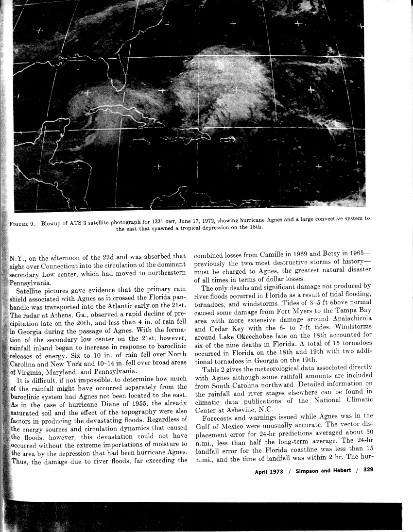
Agnes moved into the coast of the Florida panhandle as a weak hurricane. Weakening into a tropical depression over Georgia, a major trough in the Westerlies approached the cyclone, which subsequently strengthened Agnes over land back into a tropical storm in North Carolina, although it also developed a more western cyclone. The two moved in tandem, with Agnes moving offshore Norfolk, Virginia and becoming a strong tropical storm. Eventually, the western nontropical low wrapped Agnes inland, which was then absorbed over Connecticut. These cyclones led to 6-10 inches/150-254 mm of rain over North Carolina, with 10-19 inches/254-483 mm falling across the remainder of the Mid-Atlantic states. [33] The flood unleashed by the system was the greatest natural disaster in damages for the United States, up until that time. [34]
[edit] Michigan Floods - April 1975
A major flood struck the Lower Peninsula of Michigan. In early April, a foot/30 cm of snow fell across the region. Intense rainfall on April 18 and April 19 of 3-5"/75-125 mm fell over a short time frame into the residual snowpack, increasing the magnitude of the flood. The flood peaked between April 19 and April 22, primarily in the Kalamazoo, Grand, Flint, and Shiawassee River basins. The recurrence interval for this kind of flood is 50-100 years. Lansing and Flint saw the most damage, which overall totaled US$50 million (1975 dollars). [15]
[edit] Big Thompson Canyon Flood (July 1976)
Moist easterly flow went up the terrain, forming thunderstorms beginning at 6 pm and lasting to 9 pm on July 31. Eight inches/200 mm of rain fell in one hour, with over a foot of rain/300 mm falling during the event. A 19 foot high fall of water swept down the canyon, taking everything in its path downstream. It was one of the deadliest freshwater floods in U.S. history, as 145 people perished during the flash flood. Houses destroyed totaled 418. Overall damage was US$40 million (1976 dollars). In the aftermath of the storm, regulations were passed to limit development in similar canyons. [35]
[edit] New England Flood - 1978
Flooding throughout the region caused millions of dollars in damage. [9]
[edit] Tropical Storm Amelia Floods of August 1978
Tropical Storm Amelia skirted the lower Texas coast and went ashore south of Corpus Christi during the night of the July 30/July 31. The circulation was followed inland west of San Antonio on August 1 before becoming diffuse. Rainfall increased despite the lack of a surface circulation, and disastrous flooding occurred in many south Texas river basins, including the Guadalupe River and its tributaries. Extensive damage occurred, and 30 people lost their lives in the flood. The maximum rainfall total in Texas occurred in Medina, where 48 inches/1219 mm of rain was deposited due to mesoscale convective systems firing along a frontal boundary induced by Amelia's remnant circulation aloft. [36]
[edit] Decade of the 1980s
[edit] Lower Mississippi Flood of 1983
This was the second most severe flood in the lower Mississippi Basin since 1927. Red River Landing, Louisiana, was flooded for 115 days. Damages totaled US$15.7 million (1983 dollars). [37]
[edit] Flooding in the central Appalachians - November 1985
The antecedent event to this flood was the passage of Hurricane Juan to the west of the area, which led to over 7 inches/175 mm of rain in the Blue Ridge Mountains, though less than an inch to the Mountain State. After Juan passed by, an occluded system moved slowly northward from the Gulf of Mexico through the Mid Atlantic States during the first days of November, leading to significant rainfall for the central Appalachians. Local amounts of 20"/508 mm of rain were reported from West Virginia, worse than the flooding the state witnessed in 1888. [38] [39] This led to debris flows and widespread damage in the Upper Potomac River basin and Cheat River Basin in West Virginia and Virginia. Damage was severe where the South Branch joins the North Branch of the Potomac. The Paw Paw Tunnel was flooded. [8] The death toll was 50 from West Virginia.
[edit] Michigan Floods - September 1986
A slow-moving storm system moved from the central Plains into the Great Lakes. Rainfall amounts by September 10 were 8-13"/200-330 mm over a two day period. Damage was unprecedented. Dam failure abounded with a total of 14 dams undermined and an addition 19 dams at risk during the event. Four major bridges failed. Thousands of acres of sugar beets, beans, potatoes, corn, and other vegetables were in ruin. A total of six people perished during the flood. Damage totaled US$500 million (1986 dollars), and 30 counties were declared Federal disaster areas. [15]
[edit] Androscoggin River Flood - April 1987
The largest and most destructive flood in the history of this Maine river occurred. Jay's industrial section was inundated. [6]
[edit] Decade of the 1990s
[edit] May to September 1992 Alaska Floods
From May to September of 1992 in Alaska a combination of ice jams, snow melt, and heavy rains caused the worst flooding in this area. It is said to be one of the worst disasters recorded here. Rivers reached record stages during this flood.

→→
[edit] Great Flood of 1993 along Mississippi River
Soils became saturated in the fall of 1992 across the Midwest. Numerous rounds of showers and thunderstorms from mid-June into August led to significant flooding. Over 39"/1m of rainfall fell in isolated spots. Some areas of the Mississippi Valley were flooded for over 200 days, leading to destruction spread across nine states. This was the flood of record along many of the streams and rivers that feed the Mississippi and Missouri rivers. Around 50,000 homes were damaged or destroyed. The death toll was 50, and damage totaled US$15 billion (1993 dollars). [40] The result of this flood was an aggressive campaign by the federal government to buy out flooded agricultural land from willing sellers. [41]
[edit] Tropical Storm Alberto (1994) Floods in the Southeast
This tropical cyclone made landfall in the Florida panhandle before stalling south of Atlanta, Georgia. Flooding was near or at record levels for the Flint, Ocmulgee, Chattahoochee, Choctawhatchee, and Apalachicola Rivers. Americus, Georgia saw the heaviest rain in a 24 hour period, when 21.10"/536 mm was recorded. The death toll was 33, with two-thirds coming from people driving into flooded areas. Thousands of homes were destroyed. Damage totaled US$750 million (1994 dollars). [42]
[edit] May 8th 1995 Louisiana Flood
A stalled front led to excessive rains across southeast Louisiana. Rainfall up to 20"/500 mm fell across the Crescent City, with 12"/250 mm falling within a six hour period. Seven lives were lost, 35,000 homes were flooded along with thousands of businesses across southeast Louisiana. Damage estimates were around US$1 billion (1995 dollars). [43]
[edit] Northeast United States Flood of January 1996
Significant snowfall during the first 20 days of January led to a snowpack across the region. Some areas of the Northeast had received 2 to 3 times their average precipitation since December 1. Significant snowpack was in place on January 18. Then, a period significant warming took place across the East, mainly during a 30 hour period, which led to ice jam floods across western Pennsylvania and New York. Surface dew points rose into the 50s and 60s Fahrenheit/teens Celsius, which rapidly ate away at the snowpack. Then, a heavy rain event occurred along a frontal zone moving in from the west, which led to 1-3 inches/25-75 mm of rainfall between January 18 and January 19. Some areas lost 1-2 feet of snow in only 12 hours, which led to the bulk of the flooding.
The Ohio and Susquehanna rivers experienced their highest river crests since Hurricane Agnes and Hurricane Eloise. The Delaware River at Trenton, New Jersey saw its highest crest since Hurricane Connie and Hurricane Diane moved by in 1955. The South Branch of the Potomac, as well as the Cheat and Monongahela rivers in West Virginia and Pennsylvania experienced their highest levels since early November 1985, which was the flood of record for the region. A total of 33 people died during the event, with 18 from Pennsylvania and 9 from New York. It was the worst flood event for the Mid-Atlantic states as a whole since 1985. [44]
[edit] Willamette Valley Flood of 1996
It was the biggest flood for the region since December 1964. Heavy logging had occurred across the region in the previous 30 years. Above normal rainfall had been occurring since November 1 of 1995, which led to significant snowpack in the mountains by late January. Western Oregon then experienced a 6–12" (150–300 mm) of rainfall on February 5 to February 7, which in combination with temperatures rising into the 60s Fahrenheit/upper teens Celsius led to the flood. [30]
[edit] New England Flood - October 1996
A stationary front across the region drawing moisture from Hurricane Lili led to extreme rains across New England. Factories and mills in Lawrence, Haverhill, and Lowell, Massachusetts were severely impaired during the event. A total of 81 bridges needed to be rebuilt after the flood. A large portion of Hartford, Connecticut was submerged. [9]
[edit] Northern California Flood of New Year's Day 1997
Two months of heavier than normal precipitation fell across the area. In December alone, precipitation was triple normal values. A "pineapple connection" set up from Hawaii, bringing in a deep fetch of warmth and moisture into the region during the last days of December, which led to the onset of the flood. Heavy rains during the first few days of January totaled up to 30"/762 mm. [45] Rain fell at elevations up to 11,000 feet/3374 meters, prompting snow melt. The Cosumnes River bore the brunt of the flooding. The Klamath River also experienced significant flooding which led to the river permanently changing course in some areas. Massive landslides closed Highway 50. The Klamath National Forest experienced its worst flood since 1974. Damages totaled US$35 million (1997 dollars). [46]

[edit] Ohio River Valley Flood of March 1997
Six to twelve inches of rain fell upon northern Kentucky and southern Ohio between March 1 and March 3. A total of six states were impacted by the event. Record flooding was witnessed along most rivers in northern Kentucky, surpassing that of 1937. Near-record flooding was recorded in Ohio, mainly along Brush Creek and the Scioto and Great Miami Rivers. Eastern sections of Higginsport went underwater, leaving only one route in and out of town. [20] It was Ohio's worst flood in 30 years. The death toll from the event was 33, with 21 lives lost in Kentucky and 5 lost in Ohio. Hundreds were injured. [47]

[edit] Red River Flood, 1997
The prior winter was one of the snowiest on record for the northern Plains, with 117"/297 cm falling at Fargo, North Dakota. The Red River of the North is a unique one, as it is one of few in the United States to flow north. During the spring thaw, this creates problems as it is usually colder in southern Canada, which makes ice jam flooding a major concern for this river basin. Starting in early February, a major flood was anticipated, over two months before the flood. This gave the region plenty of time to sandbag the nearby dikes. The river began rising on April 4, and flooding the area on April 18 as the flood waters rose up to 5 feet above the long term prediction. Dikes gave way, and Grand Forks was inundated. Between 75-90% of the residents had been evacuated prior to this time. Fires began to break out on the 19th as electric lines shorted out, which destroyed 11 buildings in downtown. The river and associated flood waters began to recede on April 23. [48]
[edit] Fort Collins, Colorado Flood of July 1997
On July 27, upslope flow into the Front Range of the Rockies forced dewpoint temperatures to around 60F/16C. By 5 pm local time, thunderstorms began to erupt. Within 30 minutes, local amounts of 2"/50 mm had fallen near Laporte and Livermore, with 2 inches/50 mm falling near Loveland Pass before the storm weakened around 8 pm. South of Fort Collins, new thunderstorm development began around 10 pm, which spread north through the city, dumping another half inch/12 mm of rain before dissipating. Around midnight on July 28, upslope flow increased behind a cold front that triggered the initial thunderstorms. Steady rains began around 1 am, ending for the most part around 4 am for much of the region except for a narrow swath including Fort Collins, where rains continued towards 7 am. However, rains renewed across the region between 8 am and noon. An additional 6-8"/150-200 mm of rain had fallen near Laporte. By that evening, thunderstorms redeveloped. Starting at 7 pm, heavy rains fell at Colorado State University. Between 8:30 and 10 pm, very heavy rains struck Fort Collins again. A total of over 10 inches/250 mm fell during this time frame, which brought storm totals to 14.5"/368 mm in southwest Fort Collins. [49] The ensuing flood caused a freight train to derail and completely destroyed two mobile home parks. Damage totaled in the hundreds of millions of dollars. [50] This flood event helped spawn a developing rainfall mesonet for the United States, known as CoCoRAHS, which was anticipated to help catch ongoing flash flood events in real-time. [51]
[edit] Central and South Texas Flood of October 1998
A tropical connection of moisture from Hurricane Madeline intercepted a stationary frontal zone, leading to extreme rainfall. Between October 17 and October 18, rain totals of up to 22"/559 mm were recorded across central and southern Texas, which led to the flood of record in southern Texas. A total of 31 perished during the event, 17 of which were found in flooded vehicles. Damage approached US$750 million (1998 dollars). [52]

[edit] Hurricane Floyd Floods in East - September 1999
The antecedent conditions included the passage of Tropical Storm Dennis through the Mid-Atlantic states during the first week of September. Only 10 days later, the combination of a stalled frontal zone, strong dynamics aloft, and a hurricane moving up the East coast led to excessive rainfall from North Carolina northward up the Eastern Seaboard between September 14 and September 17, with amounts of near 20"/508 mm being reported near Wilmington, North Carolina, and 6-12"/150-300 mm falling farther up the coast. It was the most damaging flood in the history of North Carolina. In New Hampshire, the storm flooded Belknap, Cheshire, and Grafton counties. [3] Of the 57 deaths attributed to Floyd, 46 were due to drowning in the flood; 35 from North Carolina alone. Damage estimates were near US$5 billion (1999 dollars). [53]
[edit] Decade of the 2000s

[edit] Tropical Storm Allison Floods in Louisiana and Texas - June 2001
The remains of the tropical cyclone sat and spun over eastern Texas for several days before moving eastward just inland of the Gulf coast. Heavy rains fell along the western Gulf coast that week, with storm totals of near 37 inches/940 mm near Houston and 41 inches/1041 mm west of Beaumont. Damage from the storm was estimated near US$6 billion (2001 dollars), and 41 perished from the flood. [54]
[edit] Hurricane Katrina (2005) Storm Surge - Louisiana and Mississippi
A large category 3 hurricane at landfall along the southeast tip of Louisiana, strong northerly flow behind Katrina while weakening to category 1 strength caused breaks and failures in the levees that protected the lower Ninth ward and along other canals in New Orleans, flooding 80 percent of the city for nearly a month. The mouth of the Mississippi River saw breaks in its levee system due to storm surge. In Mississippi, a massive storm surge destroyed most structures along the coast including floating casinos, and preliminary figures show that the storm surge was higher than in Hurricane Camille of 1969. [55] There were 1353 fatalities, mostly from flooding.
[edit] Mid-Atlantic and New England Flood - October 2005
The combination of a moisture fetch set up by Subtropical Depression 22 and Tropical Storm Tammy, as well as an additional tropical disturbance which rode up a stationary frontal zone, set up excessive rains from coastal sections of the Mid-Atlantic states through southern New England. In New Hampshire, the Monadnock region was affected, with Alstead among the hardest hit as 12"/300 mm of rain fell within 30 hours, allowing this month to be the wettest in the history of the Granite State. It was considered a once in 500 year flood event. [3]
[edit] Ka Loko Reservoir - March 2006
Prolonged rains fell across Hawaii between February 19 and April 2, 2006 as upper cyclones kept closing off northwest of the archipelago, virtually eliminating their normal trade winds, and bringing some of the wettest conditions seen for the 50th state since March 1951. The heavy rain event of March 1 to March 3 brought severe flooding to the east-facing slopes of the Koolau Range in Oahu, with 22.47"/571 mm falling in two days at Punalu'u. During the next rain event from March 8 to March 11, many of the larger islands received significant rain. Flash flooding occurred in Maakua Stream, and severe inundation impacted communities from Laie to Kahana. As much as 14"/356 mm of rain fell over north Kauai forcing the closure of Kuhio Highway at the Hanalei Bridge for the second time in 24-hours. Six to 10 inches/150-255 mm of rain fell upon the southeast-facing slopes of the Big Island causing numerous road closures in Hilo. North and east Kauai experiences 8-12"/200-300 mm of rain over a 3 day period. Mount Waialeale recorded over 28"/711 mm during this 4-day period. The Kauai Marriott Resort suffered significant damage due to the overflow of Keonaawanui Stream during the early morning hours of March 11. The third significant rain event between March 13 and March 18 were too much for Ka Loko Dam in northeast Kauai, which failed during the early morning of March 14. The wall of water swept away homes and structures and resulted in 3 confirmed deaths and 4 persons missing. Repeated thunderstorms and heavy rains produced numerous road closures from flooding and inundated many properties. [56]
[edit] Mid-Atlantic Flood - June 2006
A stalled frontal boundary, a tropical connection, and a developing tropical disturbance led to heavy rains across the Mid-Atlantic and Northeast, particularly in central Maryland and Pennsylvania during late June. Rainfall amounts ranged up to 17"/430 mm during the several days of heavy rain. There was threat of dam failure around an earthen dam around Lake Needwood in eastern Montgomery County, Maryland, due to the deluge.
[edit] Western Gulf Coast Flood - October 2006

A trio of heavy rainfall events, on October 14-17, October 18-19[57], and again from October 26-27 set the stage for moderate to significant flooding across portions of eastern Texas, Louisiana, as well as portions of Arkansas and Mississippi.[58] This was the wettest spell for the region since T.S. Allison of the 1989 Atlantic hurricane season.[59] Two of these events were fed by tropical cyclones from the 2006 Pacific Hurricane Season, Norman and Paul, which impacted western Mexico. Each rainfall event led to localized maxima in excess of 10 inches, and helped break a dry spell across the region. Localized totals ranged up to 28 inches/711 mm near Kountze, Texas during the 13 day period from October 14 through October 27.
[edit] Washington State Flood of November, 2006
Severe flooding in Washington state closed Mount Rainier National Park and damaged several mountain towns, including North Bend.
[edit] See Also
- Great Flood of 1844
- Great Flood of 1993
- Hurricane Agnes
- Hurricane Camille
- Hurricane Floyd (1999)
- Hurricane Katrina (2005)
- Ka Loko Reservoir
- May 8th 1995 Louisiana Flood
- Mid-Atlantic Flood - June 2006
- Red River Flood, 1997
- Tropical Storm Alberto (1994)
- Tropical Storm Allison (1989)
- Tropical Storm Allison (2001)
- United States tropical cyclone rainfall climatology
- Willamette Valley Flood of 1996
[edit] References
- ^ a b Brad Edmondson. 1927 Mississippi River flood. Retrieved on 2006-11-30.
- ^ World Meteorological Organization. The Associated Programme on Flood Management. Retrieved on 2006-11-30.
- ^ a b c d e f g h http://www.newhampshire.com/pages/floods.cfm
- ^ a b c Stephen F. Miller Jr. The Chronological History of Natural Disasters in North Central Pennsylvania. Retrieved on 2006-11-30.
- ^ a b c d e http://www.srh.noaa.gov/shv/hydro.htm
- ^ a b c d e f g h i j http://abacus.bates.edu/acad/depts/environ/projects/AndroscogginTimeline.html
- ^ a b http://www.watervillemaine.net/history/history.html
- ^ a b c d e f http://www.potomacriverkeeper.org/cms/index.php?option=com_content&task=view&id=31&Itemid=43
- ^ a b c d http://www.nesec.org/hazards/Floods.cfm
- ^ http://www.massmoments.org/moment.cfm?mid=145
- ^ http://www.parkersburg-wv.com/pages/floodhistory.htm
- ^ http://www.johnstownpa.com/History/hist19.html
- ^ http://www.nps.gov/jofl/
- ^ http://www.drought.unl.edu/risk/us/compare.htm
- ^ a b c d e http://mi.water.usgs.gov/fdfloods.php
- ^ http://www.gvsu.edu/geology/?id=72561D13-A242-1336-A866971D1F58EA6D
- ^ a b Library of Congress American Memory Project. Selected Panoramic Photographs. Retrieved on 2006-11-30.
- ^ a b http://www2.willard.lib.mi.us/bcphotos/floods/index.htm
- ^ http://www.albionmich.com/history/histor_notebook/R990301.shtml
- ^ a b c http://www.higginsportohio.com/floods.html
- ^ http://www.city-data.com/us-cities/The-Midwest/Dayton-History.html
- ^ a b c http://www.enquirer.com/flood_of_97/history3.html
- ^ http://www.mvn.usace.army.mil/pao/RELEASES/02-06_1927_Flood_Anniversary2.htm
- ^ http://www.time.com/time/archive/collections/0,21428,c_mississippi_floods,00.shtml
- ^ http://www.publicaffairs.noaa.gov/pr97/nov97/noaa97-r248.html
- ^ http://www.apfm.info/pdf/case_studies/usa_mississippi.pdf
- ^ http://www.ohiohistorycentral.org/entry.php?rec=528
- ^ http://www.semp.us/biots/biot_369.html
- ^ http://www.wdaftv4.com/almanac/wafloods.html
- ^ a b http://zebu.uoregon.edu/1996/es202/flood.html
- ^ http://pubs.usgs.gov/of/1999/ofr-99-0518/ofr-99-0518.html
- ^ National Weather Service Forecast Office, Rapid City, South Dakota. The Rapid City Flood 30 Years Later. Retrieved on 2006-11-30.
- ^ David M. Roth. Hurricane Agnes - June 14-25, 1972. Retrieved on 2006-11-30.
- ^ National Hurricane Center. Preliminary Report for Agnes. Retrieved on 2006-11-30.
- ^ National Oceanic and Atmospheric Administration. COLORADO REMEMBERS BIG THOMPSON CANYON FLASH FLOOD OF 1976. Retrieved on 2006-11-30.
- ^ David M. Roth. Remains of Amelia - July 30-August 5, 1978. Retrieved on 2006-11-30.
- ^ http://www.srh.noaa.gov/topics/attach/html/ssd98-9.htm
- ^ http://www.wxscape.com/FWIS/election_day_1985.html
- ^ http://statejournal.com/story.cfm?func=viewstory&storyid=6382
- ^ http://www.nwrfc.noaa.gov/floods/papers/oh_1/lesson.htm
- ^ http://www.apfm.info/pdf/case_studies/usa_mississippi.pdf
- ^ <http://www.nwrfc.noaa.gov/floods/papers/oh_1/lesson.htm
- ^ http://www.mvn.usace.army.mil/pd/projectsList/home.asp?proje...
- ^ Office of Hydrology. NORTHEAST FLOODS OF JANUARY 1996. Retrieved on 2006-11-30.
- ^ http://www.news.water.ca.gov/1998.fall/SJwaters.html
- ^ http://www.watershed.org/news/sum_97/flood_workshop.html
- ^ http://www.nws.noaa.gov/oh/Dis_Svy/OhioR_Mar97/Ohio.pdf
- ^ http://www.geo.mtu.edu/department/classes/ge404/mlbroder/
- ^ http://ulysses.atmos.colostate.edu/~odie/rain.html
- ^ http://fcgov.com/oem/historical-flooding.php
- ^ http://cocorahs.org/Content.aspx?page=aboutus
- ^ http://www.nws.noaa.gov/om/assessments/pdfs/txflood.pdf
- ^ http://www.nws.noaa.gov/om/assessments/pdfs/floyd.pdf
- ^ Department of Commerce. Service Assessment: Tropical Storm Allison Heavy Rains and Floods Texas and Louisiana June 2001. Retrieved on 2006-11-30.
- ^ NOAA. Service Assessment: Hurricane Katrina August 25-31, 2005. Retrieved on 2006-10-30.
- ^ National Weather Service Office, Honolulu, Hawaii. Unprecedented Extended Wet Period across Hawaii. Retrieved on 2006-10-30.
- ^ National Weather Service Office, Lake Charles, Louisiana. Sam Shamburger and Montra Lockwood. Too Much of a Good Thing. Retrieved on 2006-10-28.
- ^ National Weather Service Office, Lake Charles, Louisiana. Sam Shamburger. Water, Water Everywhere. Retrieved on 2006-10-28.
- ^ National Weather Service Office, Shreveport, Louisiana. October 15-19, 2006 Heavy Rainfall Events. Retrieved on 2006-10-28.
[edit] Related links
- Dates in Nashville USACE History
- Environmental History of Androscoggin River
- Historic Flooding in Fort Collins, Colorado
- Historic Floods in Shreveport, Lousiaiana
- NWS Service Assessments of Significant Weather Events
- New Hampshire Floods
- North-Central Pennsylvania Floods
- Northeast Kansas Floods 1951 - 50th Anniversary
- Panoramic Photographs from the Library of Congress
- Rapid City, SD Flood - 30 Years Later
- Teton Flood Museum
- Tropical Storm Allison (2001) Page - NWS Houston/Galveston, TX]

