From Wikipedia, the free encyclopedia
[edit] Summary
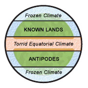
Diagram illustrating the Macrobian (Zonal Map) category of mappae mundi. The torrid (and "unhabitable") climatic zone of the equator is in red, the cold (and "unhabitable") climatic zones at the poles are in white/blue.
"Dating back to classical times, most people thought of the world as divided into zones of climate: a frozen climate at the poles, a torrid climate at the equator, and a blissfully mild (and therefore habitable) climate in between. They logically connected the temperature difference of these zones with proximity to the sun, and to a large extent they were right. Where they were wrong, however, was in their belief that the cold and torrid zones were impassable." [1]
Edited by Leinad-Z. Based on Image:Mappaemundi vertical.gif by John Hamer.
[edit] Licensing
File links
The following pages on the English Wikipedia link to this file (pages on other projects are not listed):


