Image:EnglandKent.png
From Wikipedia, the free encyclopedia

EnglandKent.png (22KB, MIME type: image/png)
| | This is a file from the Wikimedia Commons. The description on its description page there is shown below. |
 |
Permission is granted to copy, distribute and/or modify this document under the terms of the GNU Free Documentation License, Version 1.2 or any later version published by the Free Software Foundation; with no Invariant Sections, no Front-Cover Texts, and no Back-Cover Texts. A copy of the license is included in the section entitled "GNU Free Documentation License".
العربية | Česky | Deutsch | English | Español | Français | Italiano | 日本語 | 한국어 | Nederlands | Polski | Português | Slovenčina | Svenska | עברית +/- |
[edit] History on English Wikipedia
- (Delete all revisions of this file) (cur) 14:16, 14 June 2004 . . Keith Edkins (Talk | contribs | block) . . 200×247 (22,527 bytes) (Unitary shading)
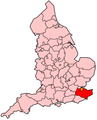
- (del) (rev) 01:36, 22 January 2004 . . Morwen (Talk | contribs | block) . . 200×247 (26,976 bytes) (map of Kent within England)
File links
The following pages on the English Wikipedia link to this file (pages on other projects are not listed):
- Kent
- User:Morwen/Allcounties
- Folkestone and Hythe (UK Parliament constituency)
- Category:Schools in Kent
- Canterbury (UK Parliament constituency)
- Ashford (UK Parliament constituency)
- Sevenoaks (UK Parliament constituency)
- Tonbridge and Malling (UK Parliament constituency)
- Maidstone and The Weald (UK Parliament constituency)
- Tunbridge Wells (UK Parliament constituency)
- Chatham and Aylesford (UK Parliament constituency)
- Dartford (UK Parliament constituency)
- Gravesham (UK Parliament constituency)
- Gillingham (UK Parliament constituency)
- Faversham and Mid Kent (UK Parliament constituency)
- Dover (UK Parliament constituency)
- South Thanet (UK Parliament constituency)
- Medway (UK Parliament constituency)
- Sittingbourne and Sheppey (UK Parliament constituency)
- North Thanet (UK Parliament constituency)
- Gillingham and Rainham (UK Parliament constituency)
- Rochester and Strood (UK Parliament constituency)
- Swimming clubs in Kent

